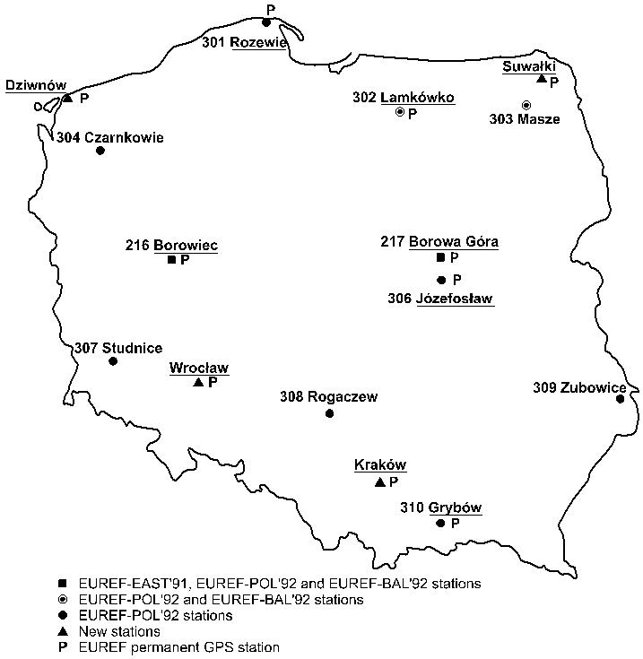
Fig. 1.1. Proposed location of the permanent EUREF GPS stations.
(compiled by Lubomir W. Baran)
This part of the Polish National Report on Geodesy is the quadrennial report on positioning works performed in Poland in a period from 1995 to 1998. It summarises the state of art of Polish national 0-order control network, its densification and link to the former geodetic control, active GPS/DGPS station network in Poland, vertical network, Polish national gravity control network, etc. The activities concerning reference networks were conducted mainly at the following research centres listed in an alphabetic order:
1.2. CONCEPT OF POLISH GEODETIC CONTROL
According to the information given in the Polish National Report presented at the XXI IUGG General Assembly in Boulder, Colorado in 1995, the EUREF network in Poland was established in 1992. The network was created as a result of the international GPS campaign EUREF-POL'92. Data from this campaign was processed and the results, including the co-ordinates of 11 stations of EUREF-POL network in ETRS'89 were presented at the EUREF Symposium in Warsaw, June 8-11, 1994.
During
data processing and analysis of EUREF-POL network its densification already
started. The establishing of POLREF network was initialised in the second
half of 1993. It materialised in monumentation of the sites of the network
starting from south-east region of Poland (Baran and Zielinski, 1996).
1.3. POLREF NETWORK – PROCESSING AND ANALYSIS
POLREF densification network is intended to provide the ETRF reference frame for geodetic, and surveying and mapping applications. The network consists of 348 points linked to 11 EUREF-POL stations. The average distance between points equals to 25-35 km. Each POLREF point consists of two observation sites: the main one and the eccentric one, separated by 2-3 km. With the existing triangulation control points coincide 209 main sites of POLREF points and 130 eccentric sites of POLREF points. Only 10 POLREF pairs are brand new control points. The monumentation of points was adopted from existing geodetic control. Normal heights of POLREF points were determined using spirit levelling with the second class accuracy standard.
The GPS POLREF campaign was conducted in three steps. Both, the first one in July 11-27, 1994 covering 108 points in south-eastern region, and the second one in October 17-27, 1994 covering 78 points were performed by the Space Research Centre of the Polish Academy of Sciences, while the third campaign that took place in April 24–May 25, 1995 covering 208 points was carried out by the Institute of Geodesy and Cartography, Warsaw (Baran and Zielinski, 1997).
The data of the POLREF campaign was processed using three different software packages: GPPS, Trimvec and Bernese. The use of Bernese software made it possible to more thoroughly analyse the data quality and to model some perturbing effects. Separately resolved two sub-networks West and East were then joined together with use of the covariance matrix. Such a solution provided an independent estimation of accuracy. The formal precision of the solution is remarkably high. It is estimated as equal to ± 0.5 mm and ± 1.5 mm for horizontal and vertical components, respectively. The discrepancy between two independent solutions West and East obtained on joint points is, however, larger by one order of magnitude; in average it equals to ± 5 mm and ± 15 mm for horizontal and vertical components, respectively. The real accuracy of the solution could be considered as not worse then ± 1 cm, that is better than the former geodetic control based on traditional terrestrial and astronomic measurements by more than one order of magnitude.
Parameters
of transformation between POLREF and the existing geodetic control were
determined using the recent geoid solution for Poland (Lyszkowicz, 1996).
It gave the possibility to assess the quality of the classical solutions
obtained within last 30 years. Their quality was found out to be quite
good; in terms of accuracy it was estimated at the level below ± 10 cm.
However, some distortions from homogeneity appear. For the JSAG-83 (1942
Reference Frame) solution the northern part of the old network is visibly
distorted with deformation exceeding 0.5 m in two opposite directions.
1.4. DENSIFICATION OF THE POLREF NETWORK
In 1996, the remaining points of the previous geodetic control were re-adjusted with the POLREF points admitted as fixed. All angular measurements were included in the re-adjustment while astronomical azimuths were not considered in computational process. The developed network consists of 6467 points. Average distances between the adjacent points amounts to about 8 km. The estimated accuracy of the horizontal position is better than ± 3 cm for 95% of points. For 28 points (about 5%) located mainly near the borders of Poland the estimated accuracy ranges from ± 5 cm to ± 8 cm.
Only latitudes and longitudes of these points are given in ETRS'89. Their heights take origin from different sources (spirit levelling or trigonometric levelling) and their accuracy is not uniform.
Points of the discussed network have been classified as first class but second order points of the Polish national network.
In
1997, the old Polish network of second class was also re-adjusted. It consists
of 61896 points. Among them there are 4005 points surveyed with GPS. The
number of observations taken to the adjustment exceeded 550000 with 48000
measured distances among them. Assuming the points of the first class as
fixed, the co-ordinates of all second class points were obtained in ETRS'89.
The relative accuracy of the obtained horizontal positions is estimated
to be better than ± 3 cm for 92% of the points.
1.5. ACTIVE GPS/DGPS STATION NETWORK IN POLAND
The first permanent GPS stations in Poland started operating within International GPS Service for Geodynamics (IGS) in 1994. Two committees of the Polish Academy of Sciences: Space and Satellite Research Committee and Committee of Geodesy, appointed a special study group in 1995. The main goal of this group was to prepare the program of development of the active GPS station network in Poland.
In the beginning the study group worked on the EUREF permanent station network project and made an assumption to establish multifunctional stations suitable for both, precise positioning and DGPS.
The study group recognised that the number of active multifunctional permanent GPS stations in Poland should be increased in the future. The distances between stations should amount about 50 km. The stations should form a new generation geodetic network, adequate for many social and economical needs (Baran and Zielinski, 1998). The local analysis centres in co-operation with national analysis centre should be engaged in processing of the permanent GPS observations.
1.5.1. Permanent GPS EUREF Stations Operating in Poland
Fig. 1.1. Proposed location of the permanent EUREF GPS stations.
According to the project elaborated in 1995 by the special study group of the Polish Academy of Sciences, it was foreseen that 10 permanent EUREF stations will be set up in Poland (Fig. 1.1) (Baran and Zielinski, 1996).
Up to now 5 stations have been established (Tab. 1.1).
Table 1.1. Permanent GPS stations in Poland
|
|
|
|
|
|
| Borowiec (BOR1) |
|
|
EUREF |
Turbo Rogue SNR 8000 |
| Borowa Gora (BOGO) |
|
|
|
Ashtech Z-12 |
| Jozefoslaw (JOZE) |
|
|
EUREF |
Trimble 4000 SSE |
| Lamkowko (LAMA) |
|
|
EUREF |
Ashtech
Z-12
Turbo Rogue SNR 8000 |
| Wroclaw (WROC) |
|
|
|
Ashtech Z-12 |
These stations belong also to the Central European GPS Reference Network (CEGRN) and EXTENDED SAGET network.
In September 1998 BOROWIEC station started to carry out the permanent double frequency P-code observations of GLONASS satellites in the frame of IGEX (International GLONASS Experiment) campaign. The observations are carried out with six channel 3S Navigation receiver, equipped with choke ring, temperature stabilised antenna.
1.5.2. DGPS Reference Stations
According to the mentioned programme, elaborated under supervision of the Polish Academy of Sciences, the creation of DGPS reference stations has been approached. Nowadays two permanent reference DGPS stations: Dziwnow and Rozewie (Table 1.2) are distributing RTCM corrections on radio frequency. They are located on the Southern Baltic seashore (Oszczak et al., 1996).
Table 1.2. DGPS stations in the Southern Baltic seashore
|
|
|
|
|
|
|
|
|
|
|
|
|
|
|
|
|
|
|
|
|
|
|
|
The
central station in Gdynia, controlling Dziwnow and Rozewie DGPS stations,
operates at the Maritime Office.
1.5.3. Some Applications of DGPS Techniques
Space Research Centre of the Polish Academy of Sciences
DGPS test network was established at the Space Research Centre of the Polish Academy of Sciences in Warsaw. The network consist of:
The Space Research Centre has carried out experiments with application of DGPS/(Low Cost IMU) configuration (Vorbrich and Zielinski, 1996). In co-operation with the Institute of Navigation of the Technical University in Brunswick (Germany) a mobile GPS laboratory equipped with an integrated DGPS/(Low Cost IMU) system was constructed. The software for the laboratory is based on own algorithms and can operate both on-line and off-line. In 1997 the DGPS/IMU navigation system was tested on Poznan racing car track.
Institute of Geodesy and Cartography, Warsaw
The Institute of Geodesy and Cartography in co-operation with NAVI Company from Poznan carries out studies on NAVI_Gsm system application to distribute DGPS corrections. This system covers most of the country.
A permanent DGPS base station is operating at the Astro-Geodetic Observatory in Borowa Gora since May 1998. The base station is equipped with Ashtech G-12 receiver with a NAVI_Gsm software. Preliminary tests show the horizontal DGPS positioning precision level below 1 m and vertical positioning precision slightly above 1m (Cisak et al., 1999).
Institute of Geodesy and Geodetic Astronomy of the Warsaw University of Technology
The Institute of Geodesy and Geodetic Astronomy in co-operation with other Polish institutions is engaged in following DGPS applications (Bogusz et al., 1998):
Institute of Geodesy, Olsztyn University of Agriculture and Technology
Since 1997 the Institute of Geodesy of the Olsztyn University of Agriculture and Technology has been engaged in experimental works on application of DGPS service for the needs of Gdansk agglomeration. Three multifunctional DGPS and RTK reference stations were established in Gdansk, Sopot and Gdynia.
The first aim of the studies is to obtain operational range of the reference stations.
Numerous experimental works on accuracy of real-time DGPS and RTK positioning were carried out in co-operation with Naval Academy in Gdynia, Maritime University in Gdynia and Maritime Office (Oszczak et al., 1996; Rzepecka et al., 1997).
In
1997, the first Ashtech GG-24 receivers in Poland were put into operation
and the field DGPS/GLONASS tests were undertaken. Intensive works on application
of DGPS/GLONASS methods in navigation, positioning and bathymetric surveys
are continued (Baran and Oszczak, 1998).
1.6.1. European Unified Vertical Reference Network (EUVN)
The main objectives of the EUVN Project are: contribution to the unification of the European height systems with an accuracy of some centimetres, providing fiducial points for the European geoid determination, connecting the European tide gauge stations at different coastlines for the investigations of sea level variations and establishing a fundamental network for further geokinematic height reference system.
The Polish part of the Project was worked out in the Department of Planetary Geodesy Space Research Centre. It consists of ten points. Some of the points are EUREF stations (Rozewie), some are geodetic observatories (Borowa Gora, Borowiec, Jozefoslaw, Lamkowko) and some of the points are UPLN (Unified Precise Levelling Network) benchmarks (Prostki, Sanok, Brudzowice, Chelmsko). The reconnaissance and the monumentation of Polish part of EUVN network were performed in autumn 1996. The campaign was carried out with TRIMBLE SSE receivers from May 21st to May 29th, 1997.
The responsibilities for the data management and data processing were distributed among the various institutions. The Department of Planetary Geodesy prepared site documents and session logs, converted raw data to RINEX, and checked RINEX headers for GPS observations for territory of Poland. As a Pre-processing Centre, the Department of Planetary Geodesy collected data and documents from Poland and United Kingdom, checked filenames for standard naming, compared file contents with logs, checked file contents for completeness, run UNAVCO’s quality Check for each file and sent data and QC output to EUVN Data Centre in Leipzig.
The entire EUVN net has been divided into eight sub-networks. Department of Planetary Geodesy processed the network, which covers the territory of Hungary, Slovakia, Poland, Latvia and Ukraine. Loosely constrained solutions according to processing standards were delivered to the EUVN Data Centre in Leipzig.
1.6.2. Modelling the Adjustment and Maintenance of the Polish Levelling System
The Polish national levelling system consists of 1st and 2nd class precise levelling networks and amounts to over 43 thousand benchmarks. The international EUVN programme assumes, among others, its integration with the ETRS'89 system, the last one realised through GPS measurements of the EUREF network. The above task is considered to be solved by adjustment of both classes of the network linked to a number of GPS reference points, as well as by its possible further systematic maintenance through repeated GPS, precise levelling and gravimetric measurements. This causes certain numerical problems reflected in the evident ill conditioning and large dimensions of matrices, cumulating round off errors, possible instability of the solution, and others. To overcome the problems it was suggested to use the so called sequential adjustment algorithm applying the sparse matrix technique.
1.6.3. Baltic Sea Level Project
The Baltic Sea Level Project was initiated already in 1989 at the IAG General Meeting held in Edinburgh to co-ordinate the vertical datum of the counties around the Baltic Sea. In order to fulfil the above goal, three Baltic Sea Level GPS Campaigns were conducted since 1990. The Third Campaign was made simultaneously with the EUVN in May, 1997. In the campaign, 35 tide gauges and 12 fiducial station were observed. Additionally, several permanent GPS stations were included in the network of the third BSL campaign.
Three
Polish tide gauges (Swiniujscie, Ustka, Wladyslawowo) and four GPS permanent
stations (Borowa Gora, Borowiec, Jozefolaw and Lamkowko) took part in the
last BSL campaign.
New Polish gravity network was established in 1994-1998. It consists of 352 gravity point with 12 absolute gravity stations (Fig. 1.2). All network points used for relative gravity measurements were monumented with the concrete pillars of size 80´ 80´ 100 cm.
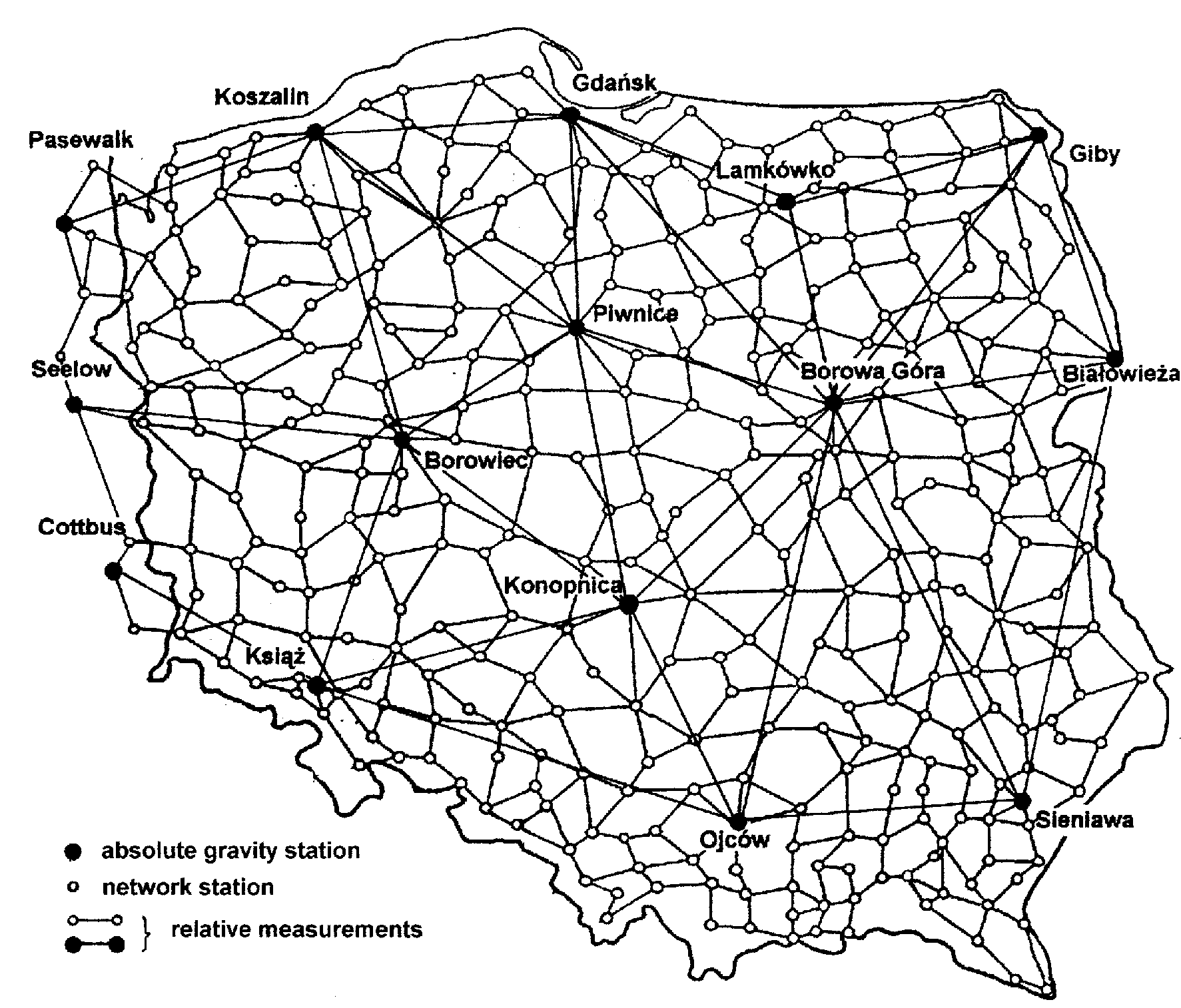
Fig. 1.2. The new Polish gravity network
Borowa Gora station, located in the Astronomic-Geodetic Observatory of the Institute of Geodesy and Cartography, was chosen as a fundamental point of the gravity network. The absolute gravity stations were located in cellar rooms of public buildings with stable geological conditions. The list of the absolute gravity stations and the description of the conducted absolute gravity measurements are given in Chapter 3 of this report.
All relative gravity measurements were carried out as independent spans. Double looping (ABAB) was completed in a day for a span between the network stations. Each span was measured simultaneously with 3 LaCoste & Romberg gravimeters. In addition 19 long spans between absolute stations were measured. Single looping (ABA) was completed in a day for a span between absolute gravity stations. It was repeated during three consecutive days with 3 LaCoste & Romberg gravimeters simultaneously. The observations were made on 720 spans between field stations. They compose 317 closed figures, of 3-5 spans each. The average length of the span in Polish national network is 35 km.
Most of the relative gravity measurements were carried out by the Institute of Geodesy and Cartography in co-operation with the Topographic Service of the Polish Army General Staff. The survey was partially performed by the Institute of Geodesy and Geodetic Astronomy, Warsaw University of Technology. The spans along and across Polish western border, measured by a German team, connected the Polish gravity network to the German absolute gravity stations at Pasewalk, Seelow and Cottbus.
Relative
gravity measurements as well as the results of absolute gravity measurements
were adjusted together. The gravity on 6 absolute stations (those which
compose two calibration base lines: Koszalin – Borowiec – Ksiaz and Gdansk
–Borowa Gora – Ojcow) was assumed to be fixed. On 90% field stations the
rms of adjusted gravity ranges from ± 4 m Gal to ± 10 m Gal, (on 99% it
does not exceed ± 12 m Gal).
Baran L.W., Zielinski J.B., (1995): Realisation of the GPS Primary Network for Poland. Status Report. Veroffentlichungen der Bayerischen Kommission fur die Internationale Erdmessung, Heft Nr 56, Munchen, pp.184-186.
Baran L.W., Oszczak S., Wasilewski A., Gasewicz B., Rzepecka Z., (1995): Determination of Airport Navigation Points in WGS 84 System of Coordinates. Proc. of the 4th Int. Conference on Differential Satellite Navigation Systems, Vol. II, Bergen 24-28 April 1995.
Baran L.W., Zielinski J.B., (1996): Polish National Report on EUREF Activities in 1995-1996. Veroffentlichungen der Bayerischen Kommission fur die Internationale Erdmessung, Heft Nr 57, Munchen, pp.288-289.
Baran L.W., Oszczak S., (1996): Vertical Datum Concept for Baltic Sea Level Studies in Poland. Proc., Geodetic Aspects of the Law of the Sea – GALOS, Second Int. Conf., Denpasar, Bali – Indonesia, 1-4 July 1996, pp.214-223.
Baran L.W., Zielinski J.B., (1997): Geodetic Reference Frame in Poland – National Report for 1996. Veroffentlichungen der Bayerischen Kommission fur die Internationale Erdmessung, Heft Nr 58, Munchen, pp.191-194.
Baran L.W., Zielinski J.B., (1998): Active GPS Stations as a New Generation of the Geodetic Networks. Geodezja i Kartografia, XLVII, No. 1-2, pp.33-40.
Baran L.W., Gajderowicz I., (1998): New Coordinate System in Poland. Proc. of the 4th Dutch-Polish Seminar, Delft, 25-27 May 1998, pp.IV.9 – IV.12.
Baran L.W., Oszczak S., (1998): Activity of the Lamkowko Satellite Observatory. National Report on Space Research in Poland to 32nd COSPAR Scientific Assembly, Nagoya, 12-19 July 1998, pp.52-54.
Beluch J., Plewako M., (1996): A Vertical Reference Frame on Mining Area Fixed on the Grounds of Classical Levelling and GPS Instrumentation. Proc. of the 6th Int. FIG Symp. on Deformation Measurements, Hannover, pp.76-88.
Bogusz J., Dobrowolski A., Kujawa L., Kurka W., Piraszewski M., Rogowski J.B., Leszczynski W., Szolucha M., (1998): Application of GPS Technology to the Environmental Studies. Reports on Geodesy, Warsaw U. of Tech., Inst. of Geodesy and Geodetic Astronomy, No 9(39).
Bruyninx C., Dousa J., Ehrnsperger W., Fachbach N., Figurski M., Johansson J., Springer T., Vespe F., Weber G., (1998): The Use of the EUREF Permanent GPS Network for the Maintenance of the European Terrestrial Reference Frame. IAG Symposia ,Vol. 118, Brunner (ed.), Advances in Positioning and Reference Frames, Springer Verlag, Berlin-Heidelberg, pp.18-26.
Cisak J., Kryński J., Witkowski T., (1999): Hourly Data Upload at BOGO Permanent GPS Station and Preliminary Attempt Toward Estimate of Quality of Collected Data. Proc. of the 5-th Intern. Sem. on "GPS in Central Europe", 5-7 May, 1999, Penc, Hungary (in print)
Czarnecki K., Fellner A., Jafernik H., Olszewski R., Rogowski J.B., Sledzinski J., (1998): RTK-DGPS for Military and Civil Aviation in Poland. Reports on Geodesy, Warsaw U. of Tech., Inst. of Geodesy and Geodetic Astronomy, No 9(39).
Felski A., (1996): Trials of DGPS in the Area of Northern Poland. Proc., The 3rd Int. Conf. of the Royal Institute of Navigation and German Institute of Navigation, EURNAV 96, Vehicle Navigation, Location and Control.
Felski A., Morgas W., Specht C., (1998): DGPS on the Baltic Sea. The Hydrographic Experience. Proc. of the XXIII General Assembly of the EGS, Symp. G16 "Geodetic and Geodynamic Achievements of the Central European Initiative (CEI)". Nice, France, 20-24 April 1998: Reports on Geodesy, Warsaw U. of Tech., Inst. of Geodesy and Geodetic Astronomy, No. 3(39), pp.217-223.
Figurski M., Rogowski J.B., (1998): CERGOP as a Regional Network for the Maintenance of the EUREF Reference Frame. Reports on Geodesy, Warsaw U. of Tech., Inst. of Geodesy and Geodetic Astronomy, No 9(39).
Gabryszewski R., Jaks W., (1995): Accuracy of Position Determination of GPS Stations in Poland. Artificial Satellites, Vol. 30, Warszawa, pp.169-173.
Kaminski W., Duchnowski R., Swiatek K., (1998): Three-Dimensional Geodetic Control Network Tied to GPS Stations. AVN, No. 11-12, pp.414-419.
Krynski J., (1995): Use of Universal Transverse Mercator Projection Co-ordinates for GPS Real-Time Navigation. Technical Report prepared for GRINEL NATAL, University of Natal, Durban, South Africa, pp.20.
Krynski J., (1997a): Height Determination in 5x5 m Grid Using Real-Time GPSTopo Survey System. Techn. Report prepared for GPS Group, Aalborg University, Aalborg, Denmark, pp.90.
Krynski J., (1997b): Determination of 5x5 m Grid Heights Using Leica 399 RTK GPS System. Technical Report, University of Natal, Durban, South Africa, pp.30
Krynski J., (1997c): Digital Terrain Model in 5x5 Grid Using Real-Time GPS Surveying. South African Journal of Surveying and Mapping, Vol. 24, Part 3, (No145), pp.121-128.
Krynski J., Swiatek A., (1997): A Regional Precise GPS Network in South Africa. Proc. of the iKUSASA CONSAS97, Durban, South Africa, 24-28 August 1997.
Krynski J., Swiatek A., (1998): Precise 3D GPS Control in South Africa. South African Journal of Surveying and Mapping, Vol. 24, Part 4, (No.146), pp.165-174.
Lyszkowicz A., (1996a): Test of the New Gravimetric Geoid in GPS Network. Rep. of Finnish Geodetic Institute, Vol. 96.2, Helsinki, pp.77-80.
Lyszkowicz A., (1996b): Conversion of Polish Precise Levelling Network into the Geopotential Numbers. Veroffentlichungen der Bayerischen Kommission fur die Internationale Erdmessung, Heft Nr 57, Munchen, pp.179-181.
Lyszkowicz A., Lyszkowicz S., (1998): Status and Statistical Properties of the Precise Levelling Network in Poland. Geodezija ir Kartografija ,Vol. XXIV, Nr. 3, Vilnius, pp.121-131.
Oszczak S., Wasilewski A., Rzepecka Z., (1995): Analysis of GPS Positioning Accuracy in Navigation Experiments at Gdansk Bay. Proc. of the 4th Int. Conference on Differential Satellite Navigation Systems, Bergen 24-28 April 1995.
Oszczak S., Baran L.W., Rzepecka Z., Wasilewski A., Dziewicki M., Lysejko A., Kopacz Z., (1996): Determination of Geodetic Positions of Baltic DGPS Reference Stations in Poland. Proc. Geodetic Aspects of the Law of the Sea – GALOS, Second Int. Conf., Denpasar, Bali – Indonesia, 1-4 July 1996, pp.398-408.
Oszczak S., Rzepecka Z., Kapcia J., Fraczyk P., (1997): Preliminary Results of Real-Time Kinematic Tests. Artificial Satellites, Journal of Planetary Geodesy, Vol. 32, No. 3, pp.157-163.
Rzepecka Z., Kapcia J., Fraczyk P., (1997): Preliminary Results of Real-Time DGPS Tests Using Motorola and Ashtech Receivers. Artificial Satellites, Journal of Planetary Geodesy, Vol. 32, No. 3, Warszawa, pp.165-174.
Rzepecka Z., Cydejko J., Dziewicki M., (1998): An Integrated GPS/GLONASS System – Field Test and Experiences with Non-differential and Differential Applications for Marine Navigation and Maritime Engineering. Proc. of GNSS98, Touluse,20-23 October 1998.
Vorbrich K., (1995): The Real-Time Positioning for Navigation Applications in Poland. Proc. 3rd Int. Workshop “High Precision Navigation 95”, April 3-6, 1995, Stuttgart, pp.318-325.
Vorbrich K., Zielinski J.B., (1996): On the Possible Application of the DGPS/(Low Cost IMU) technique. Proc. of the 9th Int. Tech. Meeting of the Inst. of Navigation – ION GPS-96, Sept. 17th-20th ,1996, Kansas City, MO, U.S., Part 1, pp.1009-1018.
Vorbrich K., Dziewicki M., Gajewski L., Stupak T., (1996): Current DGPS Maritime and Land Experiments in Poland. Proc. of the 9th Int. Tech. Meeting of the Inst. of Navigation – ION GPS-96, Sept. 17th-20th ,1996, Kansas City, MO, U.S., Part 1, pp.325-333.
Zielinski J.B., (1996): Reference Frame for Geodetic Study of the Sea Level Changes. Artificial Satellites, Vol. 31, pp.199-208.
Zielinski J.B., Lyszkowicz A., Swiatek A., Zdunek R., Gelo S., (1997): POLFER-96 – the New Geodetic Reference Frame for Poland. IAG Symposia, Vol. 118. Brunner(ed.), Advances in Positioning and Reference Frames, Springer-Verlag, Berlin-Heidelberg, pp.161-166.
Zielinski J.B., (1998): EUREF: Application of GPS for Geodesy. Proc. of the 6th European Meeting of the Civil GPS Service Interface Committee, Int. Information Subcommittee, Warsaw, pp.295-305.