(compiled by Janusz B. Zielinski)
2.1. INTRODUCTION
This part of the Polish National Report on Geodesy is the quadrennial report of works on advanced space techniques performed in Poland in a period from 1995 to 1998. It summarises investigations such as operational activity of SLR and GPS permanent stations, achievements in GLONASS observations, time transfer and time comparison, data analysis and orbit determination, modelling of ionosphere and troposphere, satellite gradiometry, etc. These activities were conducted mainly at the following research centres listed in an alphabetic order:
2.2. SATELLITE LASER RANGING
The Astro-Geodynamic Observatory (AGO) of the Space Research Centre, Polish Academy of Sciences in Borowiec is participating in the determination of the International Terrestrial Reference Frame by Satellite Laser Ranging (SLR), as the station # 7811.
The
SLR Station performs regular laser observations of 29 satellites in the
frame of international co-operation. In the period 1995-1998, 2248 observations
were completed. Borowiec AGO is a member of the International Laser Ranging
Service (ILRS) and EUROLAS Consortium, group of European SLR stations.
The observations were carried out within the following international programs:
NASA Dynamics of the Solid Earth, Working Group of European Geo-scientists
for the Establishment of Networks for Earth-science Research (WEGENER),
GeoForschungsZentrum, European Space Agency Remote Sensing Satellite, US
Naval Observatory, International GLONASS Experiment (IGEX’98). The results
of the satellite observations were delivered on a regular basis to Eurolas
Data Centre (EDC) and Crustal Dynamics Data Information System NASA (CDDIS).
The main activity of SLR team was focused on increase of the quality and
quantity of data and system automation. The overall accuracy of the system
was increased to 10 mm in the end of 1998 due to the reduction of random
errors and biases. Number of observed satellite passes increased from 1995
by a factor two mainly due to the automation of the SLR system. From 1997
Borowiec SLR participates in observations of high orbiting satellites like
GPS and GLONASS. The data from Borowiec SLR were analysed by several centers:
NASA, Center for Space Research of Texas University at Austin, Delft University
of Technology, Royal Greenwich Observatory, US Naval Observatory, GeoForschungsZentrum,
Mission Control Centre in Russia, Communication Research Laboratory in
Tokyo and the Space Research Centre in Warsaw.
2.3. GPS PERMANENT STATIONS
Five GPS permanent stations operating in Poland are listed in Table 2.1:
Table 2.1. GPS permanent stations operating in Poland
|
|
|
|
|
|
|
|
|
|
|
|
|
|
|
|
|
|
|
|
|
|
|
|
2.3.1. Borowa Góra (BOGO) GPS Permanent Station
A GPS permanent tracking station BOGO at Borowa Gora operates within EUREF permanent tracking station network from 9 June 1996. The station is equipped with the Ashtech Z-12 GPS receiver with the external rubidium atomic standard and the choke-ring Dorne Margolin antenna.
Data collected at the station is transmitted (fully automatically since mid of 1997) to the Local Data Centre at the Technical University at Graz, Austria. The entire batch of daily set of data is transmitted to Graz each day right after midnight GMT. The reliability of the station performance is estimated at the level of 0.3%.
From 17 November 1998 the permanent GPS station at Borowa Gora is taking part in the international experiment of hourly data download and transfer to the computing centre at Graz. Downloading the data, its pre-processing and transferring is set up to be fully automatic. Recently the electronic meteorological sensor is being installed at Borowa Gora and the software to download, format and hourly transfer the meteorological data to the computing centre at Graz is tested.
2.3.2. Borowiec (BOR1) GPS Permanent Station
Borowiec, since 1994 is a permanent station of IGS and EUREF services. The observations are especially important for determination of co-ordinate system for International Earth Rotation Service (IERS). GPS station participated in international and national campaigns and projects: EUREF, SAGET, Baltic Sea Level, CERGOP, POLREF, EUVN’97. The GPS observations were carried out with TurboRogue SNR 8000 receiver. The data was transmitted to the Local Data Centre in Graz (Austria) and to NASA/CDDIS on regular basis. Presently the process is fully automatic. According to the JPL Reports, a systematic increase of accuracy, particularly concerning the receiver clock stability is observed. The accuracy of phase measurements was increased and presently equals to 3 to 4 mm. The data from the BOR1 station was analysed at the Centre for Orbit Determination in Europe (CODE), JPL, EUREF, ESA/ESOC to determine Earth rotation parameters and satellite orbits.
2.3.3. Jozefoslaw (JOZE) GPS Permanent Station
The IGS permanent GPS station Jozefoslaw (JOZE) is located at the Astro-Geodetic Observatory of the Institute of Geodesy and Geodetic Astronomy of the Warsaw University of Technolology, 14 km south from the Warsaw city centre. The Observatory was established in 1959; GPS permanent service is maintained there since August 1993. Trimble 4000SSE receiver with antenna Trimble Geodetic L1/L2 are used as a basic GPS equipment. Three rubidium frequency standards are available at the station; one of them is used as an external standard for IGS service. On January 1, 1995 the second GPS receiver, a TurboRogue SNR8000 with the antenna type Dorne Margolin T was set up at the station. The permanent GPS IGS service is maintained by both receivers (Trimble 4000SSE and TurboRogue SNR8000). Trimble 4000SSE serves as the main receiver and the observations collected by this receiver are transmitted to the international data centres. The observations from Jozefoslaw are used for IGS service and for maintenance of the EUREF system. The observations from the TurboRogue SNR receiver are available upon request. Also other types of GPS receivers, i.e. Asthech Z-12, Leica and Zeiss were temporarily installed at the station Jozefoslaw in 1996 and 1997. The observations were performed to study some instrumental effects, multipath and atmospheric influences. JOZE station takes part in the works of the IGS Ionosphere Working Group.
The Jozefoslaw station is located at the distance of a few kilometres from the Warsaw airport (Warszawa-Okecie). Thus, meteorological service maintained at the station can be supported by nearby permanent meteo service of the Warsaw airport. In some periods the observations of atmospheric electricity are made at the Observatory by the team of the Polish Academy of Sciences.
The monumentation of the reference point for IGS GPS observations was made according to the IGS standards. Due to the geological conditions the pillar could not be monumented on the bedrock. Jozefoslaw station is the reference point of several international GPS networks, e.g. EUREF (European Reference Frame), EXTENDED SAGET (Satellite Geodetic Traverses), CEGRN (Central Europe GPS Reference Network realised in the frame of the project CEI CERGOP (Central European Initiative Central Europe Regional Geodynamics Project) and BSL (Baltic Sea Level Project). The eccentricity of the EUREF point with respect to that of other campaigns is X = 0.079 m, Y = 0.030 m, Z = 0.108m.
2.3.4. Lamkowko (LAMA) GPS Permanent Station
The first permanent GPS observations at Lamkowko Satellite Observatory were carried out on early 1994. First results were used to test the new TurboRogue SNR 8000 receiver. Because of lack of access to Internet the Observatory has taken a part in IGS (International GPS Service for Geodynamics) only since 1 December 1994. Observations have been transmitted to the Local Data Centre in Graz (Austria) and then to global centres of collecting and analysing data.
There are four observational pillars (LAMA, LAM1, LAM2 and LAM3) in the Observatory. LAMA is a point of global IGS network. It is also a point number 302 of the EUREF-POL network. LAMA became a point of EUVN (European Unified Vertical Network) as a result of participation in observational campaign carried out in May 1997.
In 1998 a new observational point (LAM5) was established. It is placed on the roof of Observatory building and plays a role of a reference station in experiments with RTK.
Observations are carried out by two receivers. One of them is Turbo Rogue SNR 8000. Ashtech Z-12.3 can replace it in case of its malfunction (which has taken place twice since 1994). Observatory has got its own rubidium frequency standard and meteo-station HTPL 3A made by NAVI.
The results of permanent GPS observations, obtained in Lamkowko and other Polish and European IGS stations, are used for following studies:
2.3.5. Wrocław (WROC) GPS Permanent Station
The
permanent GPS station "Wroclaw" has been established in November 1996 and
is working within the EUREF network. It is equipped with Ashtech Z-12.3
receiver and the Dorne Margolin antenna.
2.4. OBSERVATIONS OF GLONASS
In
September 1998, AGO Borowiec started, as one of the first stations in the
world, permanent, double frequency, P-code observations of GLONASS satellites.
The observations are carried out with six channel 3S Navigation receiver
equipped with choke ring temperature stabilised antenna. Participation
of Borowiec in the International GLONASS Experiment (IGEX) campaign is
a very important task for permanent determination of coordinates and time
comparison using GLONASS.
2.5. TIME TRANSFER AND COMPARISON
The
Astro-Geodynamic Observatory in Borowiec is participating in the realization
of the international atomic time scale (TAI) coordinated by the International
Bureau of Measures and Weights (BIPM) by measuring the connections of local
atomic standards with the use of GPS time receivers. The accuracy of connection
of the local time scale, generated by the EUDICS 3020 cesium frequency
standard, to the global time scale is maintained at a precision level of
± 2 ns. Another development is the time comparison by GLONASS system which
enables accuracy better than one ns. Together with US Naval Observatory,
BIPM, Van Swinden Laboratory in Holland and Royal Observatory in Brussels,
Borowiec participates in the development of this new very precise method
of clock comparisons. The expected results will be by an order of magnitude
better than the measurements available with GPS. In the near future Borowiec
will participate in time comparison by Satellite Laser Ranging in the frame
of Atom Clock Ensemble in Space (ACES) project.
2.6. DATA ANALYSIS AND ORBIT DETERMINATION
The study concentrated on the possible existence of systematic range biases, and on developing a technique to obtain optimum accuracy in geodetic network solutions. The investigated global network comprises 59 stations (see Fig. 2.1). The investigations were conducted in co-operation with the Delft University of Technology. The solutions were obtained using the software combination GEODYN II, SOLVE (NASA/GSFC), 3DMOTION (DUT).
2.
Orbit improvement of low and high satellites: ERS-1, TOPEX/Poseidon, Lageos1,
and determination of the Borowiec SLR station position in ITRF91. Simultaneously
range biases were estimated. Investigations were performed in cooperation
with ESA/ESOC/ Darmstadt. Computations were conducted using BAHN (ESOC)
software.
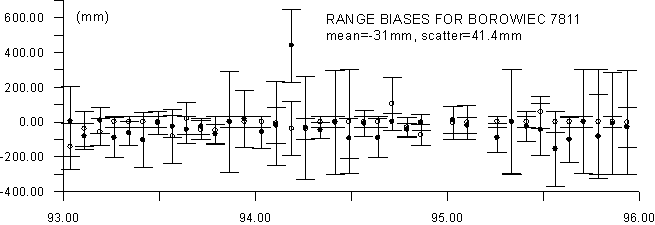
Fig. 2.1. The range bias values estimated for Borowiec
Since the mid of 1996 the EUREF Local Analysis Centre in Warsaw University of Technology (WUT) has started daily processing of GPS data from EUREF sub-network. The diagram of this network is presented in Fig. 2.2.
From 919 GPS week this sub-network is extended to north-east direction. Stations JOEN, RIGA and SVTL were included to data processing. In the same time stations MATE and KOSG were excluded. Recently the network is constrained to stations WTZR, ONSA and METS. In 1997 the antenna phase centre models were changed according to IGS standards. Other parameters of data processing remained the same as in 1996. Bernese software version 4.0 with automatic data processing was used.
Data from numerous international GPS campaigns have been processed at the Centre, e.g.:
Fig. 2.2. EUREF sub-network processed by WUT
2.6.3. Study on Influence of GPS Satellite Orbits’ Quality on Positioning Precision
Study on the influence of GPS satellite orbits' quality, determined by CODE(Centre of Orbit Determination in Europe), on precision of determination of vector components was carried out at the Institute of Geodesy of the Olsztyn University of Agriculture and Technology. The following orbits were taken into account:
The following vectors (150-1500 km long) were analysed:
Lamkowko - Borowa Gora,
Lamkowko - Borowiec,
Lamkowko - Matera,
Lamkowko - Onsala.
Data collected in January 1998 (939-942 GPS weeks) at the permanent GPS stations were processed using Bernese v. 4.0 software. The results are shown in Table 2.2.
Table 2.2. The influence of orbits’ quality on vector’s co-ordinates
|
|
in co-ordinates |
in length |
| CODE - IGS |
|
|
| CODE
1-DAY - IGS
RAPID ORBIT - IGS |
|
|
| CODE
24-pred. - IGS
(d < 300 km) |
|
|
| CODE
24-pred. - IGS
(d < 600 km) |
|
|
The analysis led to the following conclusions:
2.7. TROPOSPHERE AND IONOSPHERE STUDIES
New algorithms and software for determination of tropospheric refraction were developed in the Academy of Metallurgy and Mining in Cracow (Góral, 1997). The proposed methodology does not require information on meteorological conditions in survey points. It has been indicated that the method is particularly effective for GPS projects in mountainous areas. The analysis of GPS data burdened with multi-track effect was carried out.
The research on ionospheric delay to determine Total Electron Content (TEC) and to investigate the influence of TEC changes on the precision of positioning started in the Olsztyn University of Agriculture and Technology in 1995. The TEC can be obtained on the basis of the simultaneous two frequency observations with use of the algorithm shown in (Baran et al., 1997) at the level of precision of (2-3)*1016 el./m2.
GPS observations from IGS and EUREFF stations were used. Changes of TEC are monitored in many directions since the GPS solution requires at least 4 GPS satellites to be simultaneously observed.
The study carried out at minimum solar activity, show that two frequency GPS observations are useful for monitoring periodical (daily and seasonal) changes of TEC and for monitoring TEC at solar storms periods (Baran and Shagimuratov, 1998).
It turned out that, at ionospheric disturbance periods at minimum solar activity, at middle latitudes the TEC could rise three times over its normal value. Changes of condition of ionosphere affect the propagation along the path between the satellite and receiver. The effect can reach up to 0.3-0.5 m.
GPS
observations, carried out in 1995-1997 at the permanent IGS stations: Borowiec,
Jozefoslaw and Lamkowko, were used to create regional TEC model over Poland.
The model is valid at minimum solar activity. The local ionosphere models
over three mentioned IGS stations were used as the bases of the model.
Daily changes of the TEC were shown as expansion of Fourier series in function
of local time and seasonal changes in function of number of the month.
The model was checked by calculating the TEC value by back extrapolation.
Differences amounted to 15-40% depending on month. The obtained discrepancies
were interpreted as the result of long period changes of TEC that were
not taken into consideration in this model.
2.8. SATELLITE GRADIOMETRY
Theoretical study on satellite gradiometry was conducted in the Space Research Centre, PAS, Warsaw in cooperation with the Institute of Theoretical Astronomy, RAS, St.Petersburg, Pulkovo Astronomical Observatory, RAS. St.Petersburg, the Smithsonian-Harvard Astrophysical Observatory and the Institute of Space Physics, Frascati, Italy.
Gradiometry
is the technique which is still in the development phase. The gradiometer
developed in IFSI, Frascati, could be applied in a balloon mission or in
a free fall probe. Recently a GIZERO project has been developed, which
is essentially the facility for creation of free fall conditions. The feasibility
analysis of application of IFSI gradiometer for Earth gravity field investigation,
Free Falling Gradiometer, taking into account GIZERO project,
was carefully examined. The requirements for the gradiometric experiment
are discussed and the possible scenario of such a mission is presented
with special emphasis on the accuracy analysis and error budget of the
measuring system. Much of the attention is devoted to analytical methods
of the Earth gravity field modelling and model improvement (Petrovskaya
and Zielinski, 1997, 1998a,b, 1999). Besides of free falling probe also
orbital and airborne applications were analysed.
References
Baran L.W., Krankowski A., (1997): The Lama IGS Station. IGS 1996 Annual Report, IGS Central Bureau, Jet Propulsion Laboratory, Pasadena, California/USA, pp.353-355.
Baran L.W., Kapcia J., Krankowski A., Shagimuratov I.I., (1997): Activity of the Lamkowko Station in the Years 1994-1997. Reports on Geodesy No5(28), Proc. of the Fifth Bilateral Geodetic Meeting Italy-Poland, Monselice/Padowa, 16-19 June 1997, pp.259-264.
Baran L.W., Shagimuratov I.I., (1998): The Use of GPS for Monitoring of the Ionospheric Disturbances. IAG Symposia, Vol. 118, Brunner (ed.), Advances in Positioning and Reference Frames, Springer-Verlag, Berlin, Heidelberg, pp. 252-256.
Barlik M., Chojnicki T., Rogowski J., (1996a): Results of Tidal Observations at Geodynamical Station Józefosław. Publ. Inst. Geoph. Pol. Acad. Sci., F-20(270), Earth Tides – Marées Terrestres, Warsaw, pp.129-135.
Bogusz J., Kujawa L., Piraszewski M., Rogowski J., Sledziński J., (1997): Report on day-to-day GPS data processing performed by the Warsaw University of Technology Analysis Centre. Proc. of the General Assembly of (EGS), Symp G14 "Geodetic and Geodynamic Programmes of the CEI", Vienna, Austria, 21-25 April 1997: Reports on Geodesy, Warsaw U. of Tech., Inst. of Geodesy and Geodetic Astronomy, No. 3(26).
Bogusz J., Kurka W., Kujawa L., Piraszewski M., Rogowski J., Sledziński J., (1997): Some results of Warsaw IGS/EUREF/CERGOP Network Associated Analysis Centre. Proc. of the 7th CEI CERGOP Working Conference, Budapest, Hungary, 6 May 1997: Reports on Geodesy, Warsaw U. of Tech., Inst. of Geodesy and Geodetic Astronomy, No. 4(27).
Bosy J., Cacoń S., Kontny B., (1997a): GPS permanent station WROC. Reports on Geodesy, Warsaw U. of Tech., Inst. of Geodesy and Geodetic Astronomy, No. 4(12), pp.235-242.
Dobrzycka M., Sękowski M., Zdunek R., (1998): Conditions and Limitations of Using Permanent GPS Stations in Common Geodetic Practice. Proc. of the Conf. of Civil GPS Stations in Common Geodetic Practice, Geodezja ir Kartografija, Vol. 24, No. 4, Lithuania, Vilnius, Technika.
Figurski M., (1998a): The Effect of the Ionosphere Modelling on the Accuracy of GPS Single-Frequency Observations. Artificial Satellites, Planetary Geodesy, Vol. 33, No. 1.
Figurski M., (1998b): Local Ionosphere Model from GPS Observations. Artificial Satellites, Planetary Geodesy, Vol. 33, No. 1.
Frączyk P., Jaworski L., Lehmann M., Tyranowska A., (1998): Geodetic GPS observations in the presence of radio-frequency signal disturbances. Artificial Satellites, Vol. 33, No. 2, pp.109-115.
Gabryszewski R., Jakś W., (1995): Accuracy of position determination of GPS stations in Poland. Artificial Satellites, Vol. 30, pp.169-173, 1995. Geodesy No 28, Vol. 31, No 3, Warsaw, Poland, pp.163-177, 1996.
Góral W., (1997): Numerical estimation of differential refraction correction in GPS measurements. Reports on Geodesy, Warsaw U. of Tech., Inst. of Geodesy and Geodetic Astronomy, No. 5(28), pp.181-187.
Jakś W., Gabryszewski R., Lehmann M., (1995): Activities of the IGS fiducial station Borowiec. Artificial Satellites, Vol. 30, pp.161-167.
Jakś W., Gabryszewski R., Lehmann M., Nawrocki J., (1995): Activities of the IGS fiducial station Borowiec. Proc. of the 3rd Int. Seminar on GPS in Central Europe: Reports on Geodesy, Warsaw U. of Tech., Inst. of Geodesy and Geodetic Astronomy, Vol. 3(16), pp.241-248.
Jakś W., Lehmann M., (1996): Astro-Geodynamical Observatory at Borowiec. Annual Report IGS Central Bureau 1995, p.267.
Jakś W., Lehmann M., Tyranowska A., (1996): Comparison of Borowiec Co-ordinates Obtained from GPS and SLR Observations. Artificial Satellites, Vol. 31, pp.107-109.
Jakś W., Nawrocki J., (1996): Atomic Time Scale at Astrogeodynamical Observatory in Borowiec. Proc. Journees Systemes de Reference Spatio-Temporels 1995, pp.133-136.
Jakś W., Nawrocki J., (1995): Realisation of atomic time scale at Borowiec. Artificial Satellites, Vol. 30, pp.123-131.
Jakś W., Nawrocki J., (1995): Time Scales Comparisons using GPS at Astronomical Latitude Observatory in Borowiec. Proc. of the 3rd Int. Seminar on GPS in Central Europe, Reports on Geodesy, Warsaw U. of Tech., Inst. of Geodesy and Geodetic Astronomy, Vol. 3(16), pp.281-288.
Lehmann M., (1996): Hipparcos Catalogue and Borowiec Observations Series. Proc. Journees Systemes de Reference Spatio-Temporels 1995, pp.195-198.
Lewandowski W., Azoubib J., de Jong J., Nawrocki J., Danaher J., (1998): A new approach to international satellite time and frequency measurements ‘All-in-View’ multichannel GPS+GLONASS observations. Proc. ION GPS’97, pp.1085-1091.
Moskwiński M., Dobrzycka M., (1998): Astro-Geodetic Observatory at Borowa Góra. Proc. of the Inst. of Geodesy and Cartography, Vol. 45, No. 96, pp.7-19.
Nawrocki J., Lewandowski W., Azoubib J., (1998): GPS multi-channel common-view time transfer using Motorola Oncore receiver with CCDS standards. Proc. 12th European Frequency and Time Forum, 10-12 March 1998, Warsaw, Tele&Radio Research Inst., Warsaw, pp.510-515.
Nawrocki J., Lewandowski W., Azoubib J., (1998): Time transfer with GPS multi-channel Motorola Oncore receiver using CCDS standards. Proc. Civil GPS Device Interface Committee, Int. Information Subcommittee, 6th European Meeting, Warsaw, 11-13 Dec. 1997, Space Research Centre, Warsaw, pp.280-289.
Nawrocki J., Lewandowski W., Azoubib J., (1998): Time transfer with GPS multi-channel Motorola Oncore receiver using CCDS standards. Proc. 29th Annual Precise Time and Time Interval Systems and Applications Meeting, 1-4 Dec. 1997, Long Beach, US Naval Observatory, Washington, pp.319-328.
Oszczak S., (1996); Alternative Forms of GPS Adjustment Models with Kalman Gain Matrices. IAG Symposia, G. Beutler, G.W. Hein, W.G. Melbourne, G. Seeber (eds.), GPS Trends and Applications, Springer-Verlag, Berlin, Heidelberg.
Oszczak S. (1997): Integration of GPS with GLONASS system. Reports on Geodesy, Warsaw U. of Tech., Inst. of Geodesy and Geodetic Astronomy, No 6(29), pp.25-28.
Oszczak S., (1998): EGNOS Project - Integrating Component of the GPS/GLONASS System. Proc. of the 6th European Meeting of the Civil GPS Service Interface Committee, Int. Information Subcommittee, Warsaw 1997, pp.52-60.
Petrovskaya M.S., Zielinski J.B., (1998a): Evaluation of the Regional Gravity Anomaly from Baloon Gradiometry. Bolletino di Geodesia e Scienze Affini, Vol. 57, No. 2, pp.141-164.
Petrovskaya M.S., Zielinski J.B., (1998b): Application of Spatial Gradiometry for Constructing Quasigeoid Models. Proc. of the Second Continental Workshop on the Geoid in Europe, Budapest, March 10-14, 1998, Reports Finnish Geodetic Inst., 98:4, pp.107-112.
Petrovskaya M.S., Zielinski J.B., (1997): Determination of the Global and Regional Gravitational Fields from Satellite and Baloon Gradiometry Missions. Advances in Space Research, Vol. 19, No.11 “Orbit Determination and Analysis” ed. J.M.Dow, pp.1723-1728.
Petrovskaya M.S., Zielinski J.B., (1999): Solution of the airborne gradiometry boundary value problem for the height anomaly and gravity anomaly. Bolletino di Geodesia e Scienze Affini, Vol. 58, No. 1, pp.33-51.
Rogowski J., Piraszewski M., Figurski M., (1996): Current status of the Warsaw University of Technology Regional Network Associated Analysis Centre. ITRF Workshop Paris Observatory, 9-10 Oct..
Rogowski J., Bogusz J., Chojnicki T., (1997): Programme of the Scientific Research on the Earth's Crust Deformation Realised in Astro-Geodetic Observatory in Józefoslaw. Reports on Geodesy, Warsaw U. of Tech., Inst. of Geodesy and Geodetic Astronomy, No. 3(26).
Rutkowska M., (1995): Multi-satellite SLR analysis for the high quality network estimation. Artificial Satellites, Vol. 30, pp.1-7.
Rutkowska M., Romay Merino M.M., Schillak S., Dow J.H., (1995): Improvement of the SLR Borowiec station position in the global network ITRF91. Adv. in Space Res., Vol. 16, No 12, pp.97-100.
Rutkowska M., (1997a): Orbit analysis of the CESAR satellite equipped with the GPS on-board system. Artificial Satellites, Vol. 32, No. 2.
Rutkowska M., Noomen R., (1998): Range biases and station positions analysis for network solutions derived from SLR data. (submitted to Proc. from 11-th Int. Workshop on Laser Ranging, Deggendorf, 21-25 Sept. 1998).
Rutkowska M., Zieliński J.B., Ambrosius B.A., (1998): Analysis of 1993-1995 Borowiec SLR data: Station Positioning and range bias computation. (submitted to Advances in Space Research 1998).
Rzepecka Z., (1995): Studies of GPS Phase and Code Measurements Combinations. Artificial Satellites, Planetary Geodesy – No25, Vol. 30, No 2-3, Warszawa, pp.177-185.
Samoilenko A., Rudenko S., Schillak S., (1997): Local geodetic tie of the Borowiec-1 SLR station to GPS markers. Artificial Satellites, Vol. 32, No. 3, pp.175-184.
Schillak S., (1997): Station Performance Evaluation, Borowiec SLR (7811). Proc. of 10th Int. Workshop on Laser Ranging Instrumentation, Shanghai, 1996.Nov.11-15, China, pp.66-67.
Schillak S., (1997): Accuracy of the Satellite Laser Ranging. Proc. of 10th Int. Workshop on Laser Ranging Instrumentation, Shanghai, 1996.Nov.11-15, China, pp.208-215.
Schillak S., Bartoszak J., Butkiewicz E., (1997): Automation of the Borowiec SLR. Proc. of 10th Int. Workshop on Laser Ranging Instrumentation, Shanghai, 1996.Nov.11-15, China, pp.522-528.
Schillak S., Bartoszak J., Butkiewicz E., Schillak D., Zapaśnik S., (1997): Status Report on Borowiec SLR 1994-1996. Proc. of 10th Int. Workshop on Laser Ranging Instrumentation, Shanghai, 1996.Nov.11-15, China, pp.104-109.
Schillak S., Butkiewicz E., Bartoszak J., Schillak D., Zapaśnik S., (1995): The satellite laser ranging performed at Borowiec with accuracy to a few centimetres. Artificial Satellites, Planetary Geodesy, No 25, Vol. 30, No 2-3, Warsaw, Poland, pp.103-113.
Schillak S., Butkiewicz E., Łatka J.K., Dybczyński P., Baranowski R., Frączyk P., Sczaniecki Ł., (1996): Software of the Borowiec-2 SLR System. Artificial Satellites, Planetary Geodesy No. 26, Vol. 31, No. 1, Warsaw, Poland, pp.71-80.
Schillak S., Łatka J.K., Bartoszak J., Butkiewicz E., Schillak D., Zapaśnik S., (1996): Status Report on the Borowiec Laser Ranging Systems. Proc. of the 9 th Int. Workshop on Laser Ranging Instrumentation, Canberra, 1994.Nov.07-11, Vol. 1, Australian Goverment Publishing Service, Canberra, Australia, pp.264-272.
Schillak S., (1996): Satellite Laser Ranging in Poland 1976-1996. Artificial Satellites, Planetary Geodesy, No. 28, Vol. 31, No. 3, pp.163-178.
Schillak S., (1995): The accuracy and precision of the Satellite Laser Ranging Systems. Artificial Satellites, Planetary Geodesy, No. 25, Vol. 30, No. 2-3, Warsaw, Poland, pp.115-121.
Sledzinski J., (1996): Report on the IGS Global Station Józefosław (JOZE). IGS 1996 Annual Report, IGS Central Bureau, Jet Propulsion Laboratory, Pasadena, California, USA.