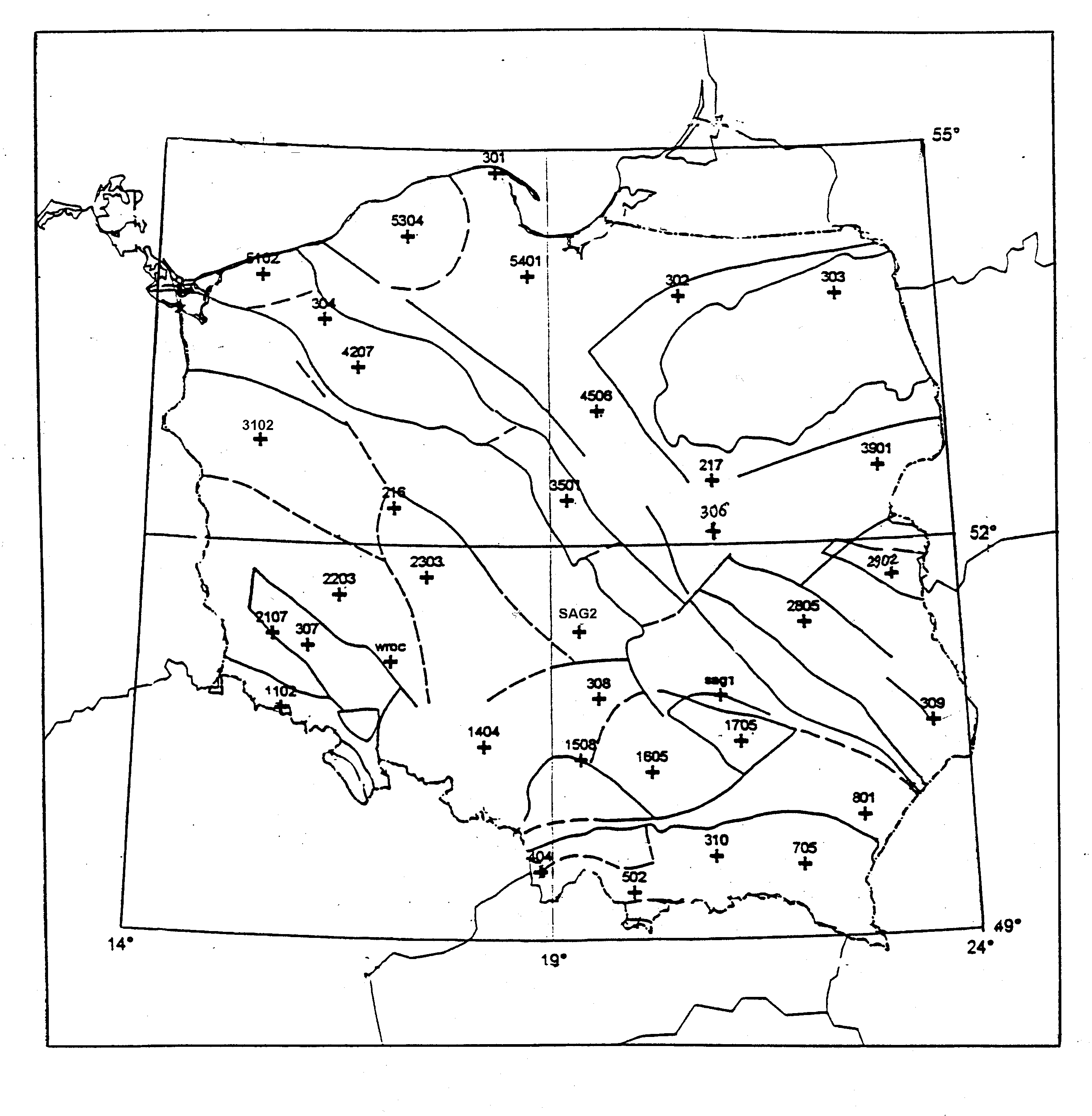
Fig. 5.1. Structure of geological blocks and distribution of points in Polish Geodynamic Network
(compiled by Barbara Kolaczek)
5.1. INTRODUCTION
This part of the Polish National Report on Geodesy is the quadrennial report of geodynamic works performed in Poland in a period from 1995 to 1998. It summarises investigations such as establishment, maintenance and analysis of geodynamic networks of continental, regional and sub-regional scale, theoretical research and analysis of Earth rotation data, Earth tides monitoring, investigations of sea level variations, etc. These activities were conducted mainly at the following research centres listed in an alphabetic order:
5.2. GEODYNAMIC NETWORKS IN POLAND
5.2.1. Polish Geodynamic Network
In the period of 1991-96 the full modernisation of the primary Polish control network was completed. Consulting geologists, 33 points of this network (including all 11 Polish 0-order EUREF points) were selected as well as 3 additional ones, setting up a repetitive Polish Geodynamic Network. The network points are nearly evenly spread all over Poland and comprise all main and secondary geological block structures. They are especially located and marked for safety with a sophisticated construction. Repetitive measurements on this network, besides other geodynamic tasks, should make possible investigations of coherency and stability of the primary control network. Distribution of the network points is presented in Fig. 5.1.
0-epoch GPS campaign on the Polish Geodynamic Network was carried out from 6 to 24 September 1997. Observations were taken over 3 days at each point (6 days at sessions joining points). However, temporary malfunctioning of two GPS receivers (lack of L2 signals, interruptions of both L1 and L2 signals) made it necessary to make supplementary observations, carried out in early October 1997 and April 1998. Eight Leica SR299, SR399 and SR9500 GPS sensors were used in the observation campaign on the network. Amending sessions were performed with the Ashtech Z-12.3 receivers.
The network was processed and adjusted in co-operation with WUT sub centre of “Permanent EUREF Network” program, using Bernese version 4.0 software, according to presently valid standards. All five Polish GPS permanent stations (BOGO, BOR1, JOZE, LAMA, and WROC) as well as stations in neighbouring countries (METS, ONSA, WTZR, GOPE and GRAZ) were used as reference points. The whole operation, designed and completed in the Institute of Geodesy an Cartography (IGiK).
Fig.
5.1. Structure of geological blocks and distribution of points in Polish
Geodynamic Network
5.2.2. Geodynamics Research In The Sudety Mountains And Fore-Sudetic Block
(SW Poland)
The research is conducted on three geodynamic polygons: “Snieznik Massif”, “Paczkow Graben”, “Stolowe Mountains”. The control networks of the mentioned polygons are integrated by a regional control network “Geosud” (Fig. 5.2). The network was established in 1996 as the geodynamic network in the Eastern Sudety Mountains and in Fore-Sudetic Block (Cacoń, 1996; Cacoń, 1998). Fig. 5.2 shows the "Geosud" network points distribution with Wrocław permanent station. In the Stołowe Mountains National Park the geodetic network was established and surveyed by GPS (Kontny and Mąkolski, 1996). Since then the GPS and terrestrial geodetic measurements are periodically repeated (Cacoń, 1998). Results obtained confirm that neo-tectonic movements are not finished yet. It indicates the potential hazard for water dams of the Lower Silesia (Cacoń and Dyjor, 1995) as well as for the other objects (Cacoń, 1998a). Recent mobility of the upper crust is also confirmed by investigations of geodynamic polygons in Snieznik Massif (Cacoń et al., 1996; Jamroz, 1997), Paczkow Graben (Cacoń and Deeb, 1995, 1996) and in the Stolowe Mountains (Cacoń, 1996a). Similar results were obtained for the Eastern Sudety and Fore-Sudetic Block (Cacoń, 1996b, 1998b; Cacoń et al., 1998). Concept of spatial database for geodynamics was presented (Kontny et al., 1997).
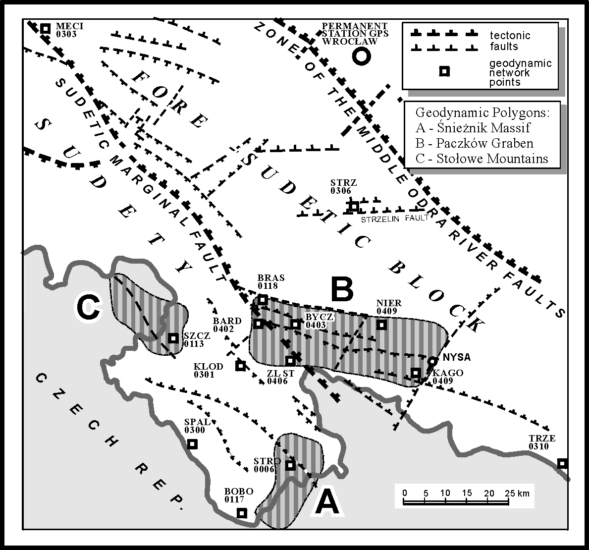
Fig. 5.2. “GEOSUD” geodynamic network
In 1997 the “GEOSUD” regional network was integrated with the “SILESIA” network in the northern part of Morava (Czech Republic) into the new network named “SUDETY” (Schenk et al., 1998).
5.2.3. Tatra Mountains Geodynamics
Geodynamic research in the Tatra Mountains Geodynamic Test Area has been initialised in mid 1980 and is carried on since. The network of well stabilised control points has been extended over a part of Slovakian Tatra Mountains. Three GPS observation campaigns were conducted in 1995, 1996 and 1998 respectively. Numerous relative gravity measurements were also conducted at the fiducial points of the control network. The final analysis of the data is being elaborated (Makowska and Cisak, 1997).
5.2.4. Geodynamic Network In Wieliczka Mining Area
An integrated geodynamic network was established in 1944-1966 within a project financed by the State Committee of Scientific Research, to monitor displacements and to analyse the sources of these displacements over Wieliczka salt mine and its surroundings. There are movements of the rock body due to seven hundred years of mining as well as due to land sliding movements and neo-tectonic movements. Geodetic network consists of numerous points stabilised on the mining area as well as intermediate points located outside this area. These points were connected to the 0-order GPS POLREF network and to a Tatra Mountains geodynamic network. GPS, levelling and gravity measurements were used for determination of a local quasi-geoid. The analysis of the results showed high effectiveness of GPS technology while monitoring displacements.
A new concept of the universal observation network for monitoring 3D displacement in mining areas and on land slide areas was described including guidelines how to carry out measurements. The concept has been verified in practice.
Verification of various hypotheses concerning the behaviour of a rock body under the influence of mining on the basis of geodetic measurements carried out periodically is presented together with a strategy of using the verified hypothesis in a kinematic model adjustment of vertical control (Beluch and Piwowarski, 1996). In areas with quick vertical dislocations a project on observation control and technology of measurements become important. Problems of collecting data from altimetry with use of technology of modular sequences located among points positioned with GPS were described. Based on finite elements a numerical model of a rock body is used. It allows to determine a deformation index at arbitrary point of the area being investigated. It is found to be an efficient tool for prediction changes and dangers caused by mining.
Application of the finite elements method for calculation of local changes of Earth gravitational field caused by a dislocation of huge masses of a rock body in open pit mines was discussed. It was proved that local changes of Earth gravitational field might have a major influence on the accuracy of precise levelling.
5.2.5. Geodynamic Network in Copper Basin Area
Polish Copper Basin is located in south-western Poland, between two towns: Lubin and Glogow. In this area the following influences of mining exploitation on the surface and the rocks mass can be established:
The precise levelling network covers the area of about 2300 km2. The study of horizontal displacements in this area was carried out using spirit levelling measurements of control points repeated every 2-3 years.
Since 1992 the new concept of 3D control network measured with GPS was developed. The primary GPS control network in the Copper Basin area consisting of 53 new points was established. The classical horizontal control network has been integrated with GPS determined one and tied to the POLREF’92 points (Wasilewski et al., 1996a; Wasilewski et al., 1996b; Baran et al., 1998).
The accuracy of co-ordinates determination, using GPS technique, of the network points was shown to be not worse than 3 mm. Performed analysis shows also high reliability of GPS measurements.
The
finite elements method for deformation analysis and prediction of displacement
is just under development.
5.3. INTERNATIONAL GEODYNAMIC NETWORKS
5.3.1. Baltic Sea Level Project
The Baltic Sea Level Project was initiated already in 1989 at the IAG General Meeting held in Edinburgh. The purpose of the project was to co-ordinate the vertical datums of the counties around the Baltic Sea.
In order to fulfil the above goal, three Baltic Sea Level GPS Campaigns were conducted since 1990. The first one was a two-week campaign held in October 1990, called the First Campaign. The results of the First Campaign were not as good as hoped for. The estimated accuracy of ellipsoidal height is not better than ± 4.6 cm.
As the First Campaign took place at the time of political unrest in the Baltic States and Russia, these counties were not able to take part in it. As soon as it was politically possible, contacts were made with the authorities of the newly independent states in order to plan and arrange the Second Baltic Sea Level Campaign. The Second Campaign conducted in June 7 -13, 1993 was performed under more favourable measurement conditions than the First Campaign, and a large volume of good data was collected (Zielinski and Zdunek, 1995). The estimated accuracy of ellipsoidal height was found to be at the level of ± 2.0 cm, which is essentially better than that in the First Campaign. The Third Campaign took place simultaneously with the EUVN, i.e. in May 1997. In the campaign 35 tide gauges and 12 fiducial stations were observed. Additionally, several permanent GPS stations were included into the network of the Third Campaign.
5.3.2. CERGOP Project
The main objectives of the project are: to integrate the geodynamic research in the Central European region based on high accuracy spatial geodetic measurements, to investigate the most profound geotectonic features in the Central European region, the Teisseyre-Tornquist zone, the Carpathians, the Bohemian Massif, the Pannonian Basin and the Alpine-Adria region as well as to provide a stable Central European GPS Reference Network (CEGRN) for sub-regional, local or across the borders investigations and deformation studies. In 1994 Austria, Croatia, Czech Republic, Germany, Hungary, Italy, Romania, Poland, Slovakia, Slovenia and Ukraine joined the Project headed by Hungary and Poland. As associated country Bulgaria joined the project in 1996.
Since 1994 four epoch monitoring GPS campaigns have been carried out on this network in yearly intervals. The CERGOP Data Centre established in 1994 in the Lustbühel Observatory at Graz, Austria. The data of the CEGRN campaigns were processed in the CERGOP Processing Centres. Originally 3 processing groups were formed (Graz, Austria; Penc, Hungary and Warsaw, Poland). A number of processing centres increased later to 8 (Bratislava, Slovakia; Frankfurt, Germany; Matera, Italy; Pecny, Czech Republic and Zagreb, Croatia. A major role in the project was played by CERGOP Study Groups (CSGs) formed by the scientists from two or more member countries. Nine of them remained active during the whole project period. The proceedings of semi-annual CERGOP Working Conferences were published in Reports on Geodesy, by the Warsaw University of Technology. The results obtained within the project were presented at the biannual International Seminar on “GPS in Central Europe”, organised by the FÖMI Satellite Geodetic Observatory, Penc, in Hungary. The proceedings of these conferences were also published in the Reports on Geodesy series.
CERGOP project was partially financed by the Programme COPERNICUS of the European Commission co-ordinated by the Institut für Angewandte Geodäsie (now Bundesamt für Kartografie und Geodäsie), Frankfurt/Main, Germany. First phase of the Project was concluded on 30 June 1998. Lately the proposal for the second phase of the CERGOP-2 Project was submitted to the European Commission with the request for financial support from the 5th Framework EU Programme.
* Eleven CEGRN stations are permanent GPS stations providing continuous monitoring capabilities for tectonic studies. The remaining 20 sites are so called “epoch stations’ that provide positioning at the measurement epochs.
* The Central European Terrestrial Reference Frame (CETRF) has been established, which suits best for geophysical and geotectonic studies of the region. The yearly monitoring of CETRF provided already significant kinematic results about intraplate tectonic motions in Central Europe. 22 stations from CEI countries (eleven CEGRN stations) are involved in permanent monitoring of the European Reference Frame (EUREF).
* The
five monographs of five particular regions in Central Europe produced by
CSG.8 “Geotectonic analysis of the region of Central Europe” can be considered
as major scientific outputs of CERGOP Study Groups. The following volumes
of geotectonic monographs were published in Reports on Geodesy series:
The Pannonian Basin (ed. Grenerczy), The Bohemian Massif (ed. Vyskočil),
The Teisseyre-Tornquist Zone (ed. Liszkowski), The Northern Carpathians
(ed. Zablotskij), and The Southern Carpathians (ed. Ioane). The monographs
summarise the latest geoscience results, available on these regions, with
particular emphasis on the project’s objectives. There is also a sixth
volume (eds. Vyskočil & Sledzinski) which contains general characteristics
of all regions, list of performed studies and a summary indicating proposals
for future investigations.
According to the requirements of the EC, the proposal must be expressed in terms of work-packages. The following work-packages for CERGOP-2 are proposed:
WP2: Maintenance and Extension of CEEGRN,
WP3: Central European Terrestrial Reference Frame,
WP4: Tropospheric Delay Estimation,
WP5: Ionospheric Modelling,
WP6: Real Time GPS Applications,
WP7:
Local Deformation Studies in Central Europe.
For
technical reasons the number of sites of the Central European GPS Reference
Network (CEGRN) was limited to 31. It is successfully supplemented by the
EXTENDED SAGET programme (initiated in 1991 by the Institute of Geodesy
and Geodetic Astronomy of the Warsaw University of Technology as an extension
of the Polish SAGET Project launched at this Institute in 1986). There
is a significant coincidence of scientific aims of both CEGRN and EXTENDED
SAGET projects. However, there are also very essential differences. The
EXTENDED SAGET network covers much more extended area and an unlimited
number of points can be incorporated to this network. This gives an excellent
opportunity to all participating institutions to connect new points to
the ITRF. EXTENDED SAGET campaigns are thought as long-term action and
will be performed every year at least in the whole of current decade. The
EXTENDED SAGET campaigns took place in the following periods:
| No. | Campaign | Date |
| 1. | EXTENDED SAGET'1992 | 1992, September 7-11 |
| 2. | EXTENDED SAGET'1993 | 1993, August 2-6 |
| 3. | EXTENDED SAGET'1994 | 1994, May 2-6 |
| 4. | EXTENDED SAGET'1995 | 1995, May 29 - June 3 |
| 5. | EXTENDED SAGET'1996 | 1996, June 10-15 |
| 6. | EXTENDED SAGET'1997 | 1997, June 4-10 |
| 7. | EXTENDED SAGET'1998 | 1998, June 27 - July 1 |
| 8. | EXTENDED SAGET'1999 | 1999, June 14 - June 19 |
In
order to increase a number of points related to the same observation epoch,
the four campaigns of EXTENDED SAGET 1994-1997 fully overlapped with CEGRN
campaigns. This will also be a case of 1999 campaign. The following conclusions
may be pointed out when comparing both projects: (1) The same standards
of GPS observations are used in both CEGRN and EXTENDED SAGET campaigns,
(2) EXTENDED SAGET network includes stations of Scandinavia and Mediterranean
Region. CEGRN is limited only to CEI countries; only some regions of Germany,
interesting from tectonic point of view, are included, (3) EXTENDED SAGET
campaigns give the possibility to connect new points to ITRF, (4) Both
networks (projects) can coexist. Campaigns of both projects may supplement
each other.
5.4. EARTH ROTATION
5.4.1. Chandler and Free Core Nutation
The Chandler and semi-Chandler oscillations were studied. The semi-annual oscillation and the semi-Chandler wobble were separated using the Fourier Transform Band Pass Filter (FTBPF), (Kolaczek et al., 1996; Kosek, 1995a; Kosek et al., 1997), (see Fig.5.3). Long period variations of their amplitudes with periods of 11-14 years were demonstrated. The correlation coefficient between the change of amplitude of the semi-Chandler wobble and the Wolf numbers is significant at the 90% confidence level. It was found out that the temporal variations with the period of 3-4 years of the amplitude of the semi-annual oscillation filtered using a wide band pass filter are simply beats from the two oscillations. Polhody of the semi-annual oscillation is a left-handed ellipse with the major axis almost parallel to the Greenwich meridian. Its amplitude is of the order of 6 mas. The polhody of the semi-Chandler wobble is circular but irregular and its amplitude does not exceed 3 mas (Kosek and Kolaczek, 1995R; 1997).
IERS C04 B270 lambda=0.0005
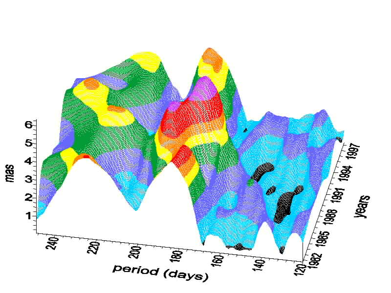
Fig. 5.3. Amplitude variations of the semi-Chandler (218 days) and the semi-annual
(182 days) oscillations of polar motion computed from the IERS C04 data
filtered by the Butterworth High Pass Filter with the cut-off period of 270 days
Variations of amplitudes of the Chandler nutation have been analysed. Oscillations with periods of 75, 40, 30, 20 years were detected by the Maximum Entropy Spectral Analysis in variations of the Chandler nutation amplitude. The oscillation with the period of 40 years is the most energetic and suggests the influence of variations of the Earth magnetic field which have the similar oscillation.
Predictions of Chandler nutation amplitude variations using the least squares and auto-regression methods show a deep minimum of the Chandler nutation amplitude at the beginning of the 21 century. Similar minimum took place at end of the 1920’s/beginning of the 1930’s (Kolaczek and Kosek, 1998).
5.4.2. Free Core Nutation
A maximum likelihood method (MLM) algorithm for direct determination of the Free Core Nutation (FCN) parameters was developed. It consists in tracking the freely excited variable FCN signal in the celestial motion of the pole observed by VLBI technique, and fitting the resonance parameters. The VLBI observations yield the FCN period estimate T=425.9± 7.9 days which confirms earlier claims that its true value is significantly shorter than 460 days theoretically predicted; on the other hand this estimate is also by about 5 days shorter than previous results from indirect estimation. The MLM estimate of the FCN quality factor is Q=40280 with 1-s confidence interval (13710,? ), that is up to one order of magnitude higher than previous indirect estimates. Comparison with the atmospheric angular momentum data shows that nearly diurnal variations of the surface pressure have enough power to excite the FCN oscillation to the observed level of 0.2 to 0.5 mas, while the wind contribution is negligible (Brzeziński, 1996b; Brzeziński and Petrov, 1998).
Application of the FTBPF to the series of nutation corrections EOP 97C04 determined by the IERS allows to determine time variable spectrum of the FCN amplitude in 1984-1996. The amplitude of the FCN is of the order of 0.2-0.3 mas at maximum and decreases since 1984. The short time-span of the data does not allow to state whether this amplitude is diminishing or it has long period variations (Kosek et al., 1998R).
5.4.3. Variations of Semiannual and Subseasonal Oscillations of Polar Motion
Time variations of amplitudes of semi-annual and short period oscillations with periods of about 30, 50-60, 90-100, 120 days of polar motion and Atmospheric Angular Momentum were determined using the FTBPF (Kolaczek, 1995; Kolaczek and Kosek, 1996; Kosek et al., 1998a), (see Fig. 5.4).
5.4.4. Prediction And Irregular Variations Of Polar Motion
The auto-covariance method of polar motion prediction was elaborated (Kosek, 1997). Prediction of polar motion was computed using the least squares model of the Chandler circle and annual ellipse together with the auto-covariance prediction of the residuals obtained after removing the least squares model. The accuracy of polar motion prediction was increased by a factor two with respect to the current prediction model for about 60-250 days in the future (Kosek et al., 1995a, 1998a).
Irregular variations of short period oscillation of the polar motion containing oscillation with periods ranging from 20 to 150 days were detected. The least squares method along with the auto-covariance prediction method were applied to determine variations of amplitudes and phases of these oscillations The largest irregular variations of amplitudes of short period variations of polar motion took place at the beginning of 1985, 1988 and 1990, which correspond to the epochs of El Nino events (Kosek and Kolaczek, 1995b). Similar irregular variations occurred in the atmospheric angular momentum variations of polar motion.
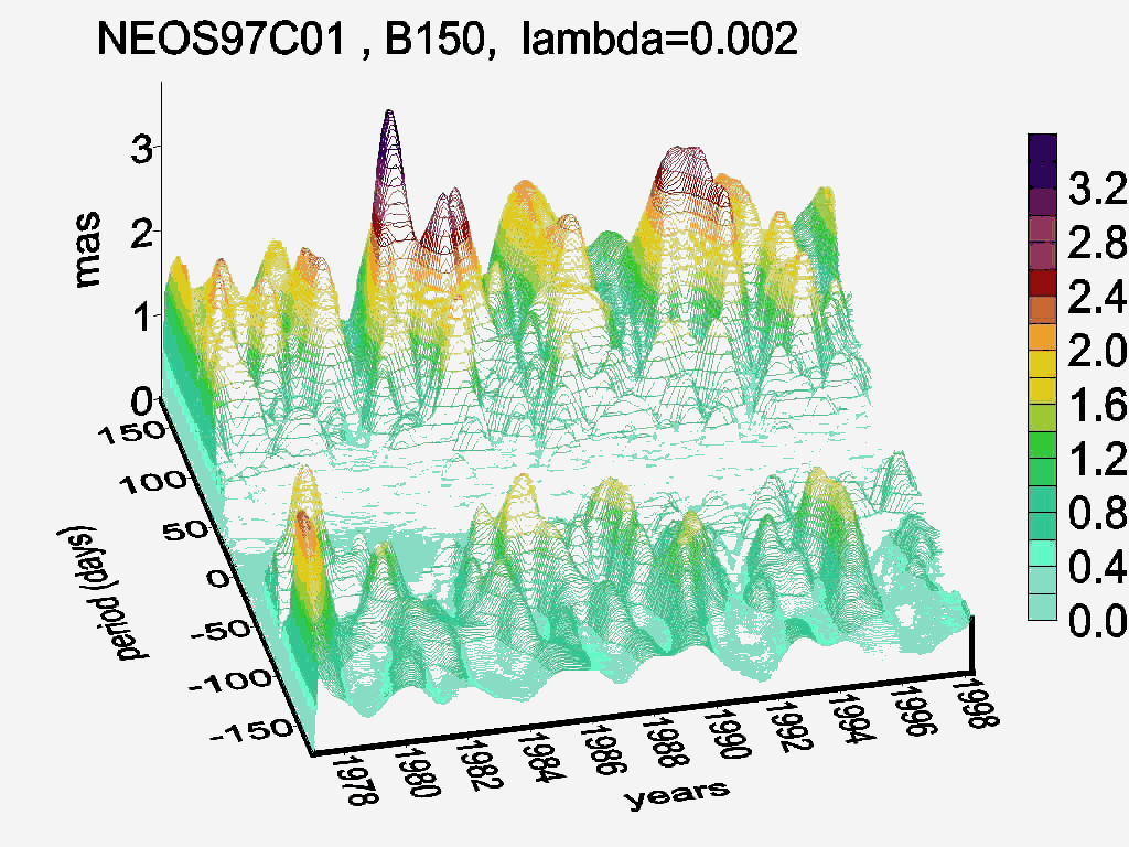
Fig.5.4. Amplitude variations of short period oscillations of polar motion with periods
ranging from 30–150 days computed from the NEOS C01 polar motion data
filtered by the Butterworth High Pass Filter with the cut-off period of 150 days
5.4.5. Analysis of Polar Motion Data
An application of the stochastic models of polar motion in algorithms of processing and interpreting Earth orientation data (Kalman filter, least squares collocation) was investigated in detail. It includes both theoretical studies and numerical experiments proving clearly a superiority of the stochastic modelling over classical methods (Petrov et al., 1995; 1996). One particular phenomenon studied in detail concerns the atmospheric normal modes which have considerable effects on Earth rotation (Petrov and Brzeziński, 1996; Petrov et al., 1997; Petrov, 1998).
5.4.6. Theoretical Problems
Theoretical investigations concerning geophysical interpretation of modern Earth rotation observations and the related geophysical data have been continued. This subject includes the definition of the Celestial Ephemeris Pole (Brzeziński and Capitaine, 1995; Brzeziński, 1998) and the equation of polar motion (Brzeziński, 1996a; Zharkov et al., 1996).
5.4.7. Regional Atmospheric Angular Momentum And Its Impact On Polar Motion
The regional values of the effective atmospheric angular momentum had been obtained from the Japanese Meteorological Society data (Nastula, 1995, 1997; Nastula et al., 1998b; Nastula and Kotreleva, 1998Ra) and from NCEP/NCAR Reanalysis Project a nearly 40 years long data series (Nastula and Salstein, 1998a, 1999). In co-operation with Atmospheric and Environmental Research Inc. (AERI), Cambridge, MA, USA, ways in which different regions are responsible for excitations of high frequency polar motions were explored using a much longer and more reliable data set than it was previously available (Nastula and Salstein, 1998a, 1999). The earlier results of Salstein and Rosen from the AERI, who found maxima in the atmospheric excitation function over the extra-tropical South Pacific, North Pacific, and North Atlantic, and Nastula, who showed that short period oscillations of polar motion excitation are mainly coherent with pressure variations over northern mid-latitude land, were expanded. Here, the Eurasian region was isolated, as particularly important for exciting high frequency polar motion (Nastula and Salstein, 1998a, 1999). The propagation of signals with these periods into Eurasia from areas west of that region was also documented. One of the most interesting results is the discovery that at northern mid-latitudes the coherence between short period variations of atmospheric excitation and polar motion depends only weakly on the inverted barometric correction.
It is clear, however, that the atmospheric data do not explain all origins of the observed high frequency polar motion signals. This lack of full agreement is likely due to the existence of other forcing mechanism. With regards to the latter, a candidate for such forcing is the ocean. The addition of oceanic excitation to atmospheric excitation, leads to a substantial improvement in the agreement between observed polar motion at seasonal and intraseasonal periods (Nastula et al., 1998Rb; Nastula and Ponte, 1999). To estimate equatorial excitation functions for the ocean the velocity and mass fields from the constant density ocean model by R.M. Ponte AERI) was used.
Analysis of the influence of shallow seas (with depth not exceeding 500m) and shelf areas on the variations of atmospheric angular momentum was performed. It was concluded that for the range from 10 to 150 days the maximum contribution from seas to standard deviation of atmospheric angular momentum could be about 40% (Nastula and Manabe, 1997). This region does not have, however, any significant influence on the change of the correlation coefficient between atmospheric angular momentum and polar motion excitation. The changes of the amplitude of atmospheric angular momentum function are 100 to 300 times smaller than the changes of the shallow and shelf sea regions (Nastula and Manabe, 1997).
5.4.8. Atmospheric Excitation of Nutation
A 29-year time series of 6-hourly atmospheric angular momentum estimates has been used to study the atmospheric influence on nutation. The most important contributions are found for the pro-grade annual (0.077 mas), retrograde annual (0.053 mas), pro-grade semi-annual (0.045 mas) nutation waves, and for the constant offset of the pole (0.115 mas). These are significant results from the point of view of both the accuracy of geodetic determinations (about 0.030 mas) and the assumed accuracy of the new non-rigid Earth theory of nutation (0.005 mas). A comparison of the atmospheric excitation and VLBI nutation data yields high correlation after 1989, which is an important confirmation of the derived results (Bizouard et al., 1997; 1998).
5.4.9. Diurnal/Semidiurnal Atmospheric and Oceanic Excitation
The estimation of the atmospheric contribution to the nutation amplitudes has been extended to the whole diurnal and semi-diurnal bands in polar motion and length of day (LOD) (Petrov, 1998; Petrov et al., 1998a). The first estimation of the non-tidal oceanic influence on nutation has been completed, where "non-tidal" means fluctuations of the oceanic angular momentum driven by the observed variations of the surface atmospheric pressure and winds. Comparison with the VLBI nutation data shows that the global ocean circulation model used in the analysis is not realistic within the diurnal band, nevertheless such a comparison provides important information on how to improve this model (Petrov et al., 1998b).
5.4.10. El Nino Impact On Polar Motion
The influence of El Nino phenomena on variations of LOD have been studied by many authors. El Nino influence on polar motion has not been studied but the correlation of El Nino phenomena with the influence of Atmospheric Angular Momentum (AAM) on the polar motion was analysed. Correlation coefficients between two El Nino parameters, differences of sea surface temperatures and sea surface atmosphere pressure in different regions of Pacific Ocean and variations of correlation coefficients between (AAM) and polar motion were computed for several El Nino phenomena. El Nino phenomena disturbs correlation coefficients between the AAM and polar motion and causes also impulsive irregular variations of short period oscillations in polar motion (Kosek et al., 1995c; Kolaczek et al., 1998a, 1998b; Nuzhdina at al., 1997R).
5.4.11. Methods
The method of time variable spectrum was developed using a band bass filter (Kosek et al., 1995c). This method enables to compute the instant amplitudes of oscillations as a function of time and oscillation periods. The application of the FTBPF enables fairly good frequency resolution of an amplitude spectrum. The time and frequency resolutions of such time variable spectrum can be changed by only one lambda parameter (Kosek, 1995a; Popiński and Kosek, 1995a, 1995b). It is also possible to determine polarisation of oscillation in complex valued time series. Such analysis revealed that short period oscillations of polar motion have variable amplitudes and they are mostly counter-clockwise (Kosek et al., 1995c, 1998a).
The new auto-covariance prediction method was developed and the computation program was written. This method enables the prediction of stationary time series without any a-priori information (Kosek, 1997).
The
Maximum Entropy Method (MEM) of spectral analysis has been developed for
the purpose of interpretation of the observed changes in Earth orientation
(Brzeziński, 1995a). This method allows to extract new information from
the series of observations analysed so far and to better interpret recent,
highly accurate measurements of UT1 and polar motion. A self-contained
package of FORTRAN programs for the MEM spectral and cross-spectral analysis
together with its description has been made available (Brzeziński, 1995b).
5.5. EARTH TIDE INVESTIGATIONS IN POLAND IN 1995–1998
Space Research Centre is carrying out tide gauge observations at the Ksiaz station (horizontal components) and at the Warsaw station (vertical component). At the Ksiaz station observations are made using Blum's pendulum and the observational series is already 25 years long. In Warsaw observations are made with the LaCoste&Romberg gravimeter and observed data are collected for 17 years (up to 1995 with the Askania Gs-11 gravimeter).
Annual series of tidal observations is analysed and then the results are published. At the same time the observations are delivered to International Centre for Earth Tides in Brussels. On the basis of existing observations the following works have been done:
- determination
of the recent vertical crustal movement at the Ksiaz station. The results
of investigations show oscillating character short time vertical movement
and linear character long time vertical movement.
5.6. VARIATIONS OF SEA LEVEL
Short period oscillations with periods of 182, 120, 90, 60 and 30 days of sea level anomalies determined from altimetry measurements of TOPEX/Poseidon were detected using the FTBPF. These oscillations have amplitudes ranging in maxima from 7 cm in case of the semi-annual oscillation to 2-3 cm for the shortest ones (Kolaczek et al., 1997R). Amplitudes of these oscillations vary with geographic latitudes, longitudes and time (Kosek and Kolaczek, 1998; Kosek 1998R), (see Fig. 5.5). Time variable spectra of these variations for all oceans were computed. A correlation of these oscillations with the atmospheric pressure variations was also found (Nastula et al., 1998R)
The
spectral analysis and filtration of the sea surface topography was conducted
using the 2D Fourier transform. The analysis enables detection of the most
energetic waves in sea surface topography and estimation of sea surface
correlation along parallels and meridians. Results show that the sea surface
waves along the parallels have larger periods than those along the meridians
all over the oceans (Popiński and Kosek, 1998R).
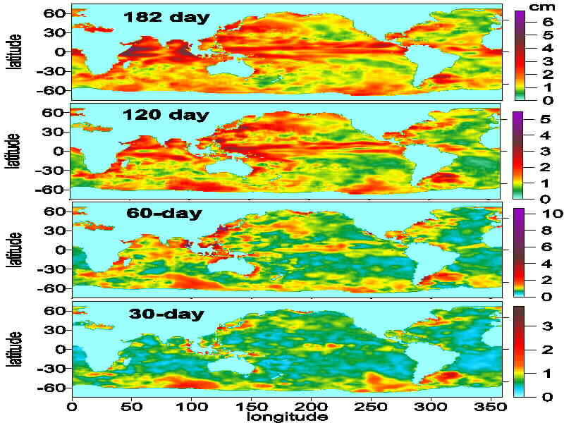
Fig. 5.5. Mean amplitudes of semi-annual and short period oscillations with periods
of 120, 60, 40 days computed by Fourier Transform Band Pass Filter from 167
cycles of sea level anomalies determined from TOPEX/Poseidon altimetry data
References:
Baran L.W., Oszczak S., Wasilewski A., Rzepecka Z., Kurpinski R., (1998): Application of GPS Technique for Monitoring of Copper Basin Area in Poland. Geodynamics 1/1998, Lviv, pp.59-63.
Barlik M., (1996): Investigations of the Earth’s figure parameters as a consequence of its innern structure. Reports on Geodesy, Warsaw U. of Tech., Inst. of Geodesy and Geodetic Astronomy, No. 3(21).
Barlik M., (1997): On the application of gradientometric measurements in determining the separation between the geoid and Molodensky’s quasi-geoid. Reports on Geodesy, Warsaw U. of Tech., Inst. of Geodesy and Geodetic Astronomy, No. 2(25).
Barlik M., (1997): Progress Report of the CERGOP Study Group CSG.7 "CERGOP Gravity Network". Proc. of the “7th CEI CERGOP Working Conference” Budapest, 6 May 1997: Reports on Geodesy, Warsaw U. of Tech., Inst. of Geodesy and Geodetic Astronomy, No. 4(27).
Barlik M., (1998): Incorporation of the vertical gravity gradient observations to the determination of separation between geoid and quasigeoid on Poland territory. Proc. of the XXIII General Assembly of the EGS, Symp. G16 "Geodetic and Geodynamic Achievements of the Central European Initiative (CEI)". Nice, France, 20-24 April 1998: Reports on Geodesy, Warsaw U. of Tech., Inst. of Geodesy and Geodetic Astronomy, No. 9(39).
Beluch J., Piwowarski W., (1996): The non-stationary description of the field of the Earth dislocations as a attempt at investigation of the stability of the reference frame of the geodetic network. Geodezja i Kartografia, No. 1, Warszawa, pp.13-31.
Bizouard Ch., Brzeziński A., Petrov S., (1997): Variability of nutations: can it be driven by the atmosphere?. Proc. Journees Systemes de Reference Spatio-Temporels 1997, Astronomical Inst., Academy of Sciences of the Czech Rep., pp.73-76.
Bizouard Ch., Brzeziński A., Petrov S., (1998): Diurnal atmospheric forcing and temporal variations of the nutation amplitudes, Journal of Geodesy, Vol. 72, pp.561-577.
Bogusz J., Kujawa L., Kurka W., Piraszewski M., Rogowski J., (1997): Computation of Velocities of Some Central European Stations from Data Processing of CEGRN Campaigns. Reports on Geodesy, Warsaw U. of Tech., Inst. of Geodesy and Geodetic Astronomy, No. 3(26).
Bosy J., Cacoń S., Kontny B., (1997a): GPS permanent station WROC. Reports on Geodesy, Warsaw U. of Tech., Inst. of Geodesy and Geodetic Astronomy, No. 4(12), pp. 235-242.
Brzeziński A., (1995): On the interpretation of maximum power spectrum and cross-power spectrum in earth rotation investigations. Manuscripta Geodaetica, Vol. 20, pp.248-265.
Brzeziński A. (1998): Contribution to the discussion concerning the definition of the Celestial Ephemeris Pole. Proc. Journees Systemes de Reference Spatio-Temporels 1998, Paris Observatory, (in press).
Brzeziński A, (1996a): "Broad band" Liouville equation of polar motion. Publ. Inst. Geophys. Pol. Acad. Sci. Vol. M-18 (273), pp.173-181.
Brzeziński A, Capitaine N., (1996): Celestial Ephemeris Pole (definition, observability and determinations). Proc. Journees Systemes de Reference Spatio-Temporels 1995, Space Research Centre Pol. Acad. Sci., pp.53-60.
Brzeziński A., (1996b): The free core nutation resonance in Earth rotation observability and modelling. Proc. of the Russian Conference "Modern Problems and Methods of Astrometry and Geodynamics", St.Petersburg, pp.328-335.
Brzeziński A., Petrov S., (1998): Observational evidence of the free core nutation and its geophysical excitation. Proc. Journees Systemes de Reference Spatio-Temporels 1998, Paris Observatory, (in press).
Cacoń S., (1998): Recent deformation of the crust in the Eastern Sudeten and surrounding areas. Proc. of 9 Int. Symp. on Recent Crustal Movement, CRCM ’98, Cairo, Journal of NRIAG, (in press).
Cacoń S., (1996): GPS-Satelliten Beobachtungen in Geodynamikforschungen Niederschlesiens. INTERGEO, 80 Geodätentag “Vermessungs-Brücke über Grenzen”, Dresden’96, Sonderdruck 24, Verlag K. Wittwer, Stuttgart, pp.223-232.
Cacoń S., (1998): The measurements and monitoring system with GPS – the basis for reliable data on deformation of an engineering object. Proc. of FIG XXI Int. Congress, Vol. 6, Brighton, pp.530-540.
Cacoń S., (1998): Recent deformation of the crust in the Eastern Sudeten and surrounding areas. Proc. of 9. Int. Symp. on Recent Crustal Movements, CRCM’98, Journal of N.R.I.A.G. Cairo, (in press).
Cacoń S., Deeb F., (1995): The influence of water reservoirs on crustal deformations in an active tectonic trough. Proc. of 5 Int. Symp. on Land Subsidence, FISOLS’95, Hague, A.A. Balkema, Rotterdam, pp.123-128.
Cacoń S., Deeb F., (1996): Deformations of engineering objects and their effect on upper lithosphere layer in their vicinity – feedback. Proc. of 8 Int. Symp. FIG on Deformation Measurements, Hong Kong, pp.345-350.
Cacoń S., Dyjor S., (1995): Neotectonic and recent crustal movements as potential hazard to water dams in Lower Silesia. Folia Quaternaria 66, Kraków, pp.59-72.
Cacoń S., Weigel J., Švabenský O., Kontny B., Jamroz O., (1996): Geodynamic structure of the Śnieżnik Massif and the adjacent areas in Śnieżnik Massif -changes in the natural environment. Publ. by Polish Ecological Agency, Warsaw, pp.57-70.
Cacoń S., Kontny B., Bosy J., (1998): Recent geodynamics in the Eastern Sudety Mts. and foreland. Proc. of EGS Symp. G16 Geodetic and Geodynamic Achievement of the CEI, XXII General Assembly of EGS, Nice, France, 1998: Reports on Geodesy, Warsaw U. of Tech., Inst. of Geodesy and Geodetic Astronomy, No. 9(39), pp.115-124.
Chojnicki T., (1995): Earth tides observations at polish permanent stations 0905 and 0906. Proc. of the XII Int. Symp. on Earth Tides, Beijing 93, Science Press. Beijing, New York, pp.115-127.
Chojnicki T., Blum, P.A., (1995): Determination of the recent vertical crustal movement as side-product of tidal observations. Proc. of the 1-st Turkish Int. Symp. on Deformations, Istanbul - 94, TMMOB-HKMO, Ankara, Vol. 1, pp.391-398.
Chojnicki T., (1996): Results of gravimetric observation of Earth tides in 1992-1993 at the Warszawa station no. 0905. Publ. Inst. Geophys. Pol. Acad. Sci., Vol. F-20 (270), pp.91-127.
Chojnicki T., (1996): Seasonable modulation of tidal waves 1993. Publ. Inst. Geophys. Pol. Acad. of Sci., Vol. F-20 (270), pp.137-156.
Chojnicki T., (1996): Earth tide investigation in Poland. Publ. Inst. Geophys. Pol. Acad. Sci. Vol. M-18 (273), pp.183-190.
Chojnicki T., Weiss J., (1996): Results of clinometric observation of Earth tides in 1991-1993 at the Książ station no. 0906. Publ. Inst. Geophys. Pol. Acad. Sci., Vol. F-20 (270), pp.3-90.
Chojnicki T., (1997): Simultaneous tidal observations using two variants of the modernised Gs-11 gravimeter: "BN" (Bonatz) and (Dittfeld-Neumeyer). Bull. d'Informations des Marées Terrestres, Vol. 127, pp.9750-9756.
Chojnicki T., Blum, P.A., (1996): Analysis of ground movements at the Książ observatory in 1974-1993. Artificial Satellites, Vol. 31, No. 3, pp.123-129.
Chojnicki T., Kaczorowski M., Bogusz J., (1998): New tidal stations in Poland. Proc of the XIII Int. Symp. on Earth Tides, Bruxelles, July 1997, pp.173-181.
Dobrzycka M., Sękowski M., Zdunek R., (1998): Polish Geodynamic Network. Proc. of the Conf. of Civil GPS Stations in Common Geodetic Practice, Geodezja ir Kartografija, Vol. 24, No. 4, Lithuania, Vilnius, Technika.
Fejes I., Ghitau D., Marchesini C., Mojzes M., Pesec P., Reinhart E., Simek J., Sledzinski J., Vodopivec F., Zablotskij F., (1997): The Central Europe Regional Geodynamic Project (CERGOP). First Results and Future Perspectives. Proc. of the General Assembly of the EGS, Symp. G14 "Geodetic and Geodynamic Programmes of the CEI", Vienna, Austria, 21-25 April 1997: Reports on Geodesy, Warsaw U. of Tech., Inst. of Geodesy and Geodetic Astronomy, No. 3(26).
Fejes I., Sledzinski J., (1997): Report of the Chairmen. Proc. of the 7th CEI CERGOP Working Conference, Budapest, Hungary, 6 May 1997: Reports on Geodesy, Warsaw U. of Tech., Inst. of Geodesy and Geodetic Astronomy, No. 4(27).
Ivankiv J., Dultsev A., Zablotskij F., Tretiak K., Sledzinski J., (1997): Establishment of the International Geophysical Station Pip-Ivan (2022m) in Eastern Carpathians. Proc. of the General Assembly of the EGS, Symp. G14 "Geodetic and Geodynamic Programmes of the CEI", Vienna, Austria, 21-25 April 1997: Reports on Geodesy, Warsaw U. of Tech., Inst. of Geodesy and Geodetic Astronomy, No. 3(26).
Jamroz O., (1997): Application of absolute and relative methods to geodynamical investigations of Śnieżnik Kłodzki Massif. Journal of Agricultural U. of Wrocław, Geodesy XIV, 324, pp.189-200.
Kolaczek B., (1995): Short Period Variations of Earth Rotation. Proc. Journees 1995 "Systemes de Reference Spatio-Temporels", Space Research Centre Pol. Acad. Sci, Warsaw, Poland, Sept. 18-20, 1995. pp.147-154.
Kolaczek B., Kosek W., (1996): Outline of Characteristics of Polar Motion Determined by Observations. Publ. of the Inst. of Geophys., Pol. Acad. Sci., M-18(273), Teisseyre R. (ed.), Warsaw, Poland, pp.163-170.
Kolaczek B., Brzeziński A., (1998c): Investigations of Earth rotation and fundamental co-ordinate systems. In.: B. Kołaczek and M. Barlik, Geodynamic investigations on the threshold of XXI century, Geodezja i Kartografia, Vol. XLVII, 1-2, pp.41-57.
Kolaczek B., Kosek W., (1998): Variations of the amplitude of the Chandler oscillation. (submitted to Proc. of Journees 1998 Systemes de Reference Spatio Temporels, Conceptual, conventional and practical studies related to Earth rotation, Sep. 21-23, 1998, Paris Observatory, Paris, France).
Kolaczek B., Nuzdhina M., Nastula J., Kosek W. (1998a): El Nino impact on atmospheric and geodetic excitation Functions. (submitted to J.G.R).
Kolaczek B., Nuzhdina M., Nastula J., Kosek W., (1998b): El Nino Impact on Polar Motion. (submitted to IERS Technical Notes No 26, IERS, Paris, France).
Kolaczek B., Kosek W., Cheng M., Nuzhdina M., Popiński W., (1997R): Short period oscillations of sea level anomalies determined from TOPEX/Poseidon altimetric measurements. Report No 30, Space Research Centre Pol. Acad. Sci., Warsaw, Poland.
Kontny B., Bosy J., Mąkolski K., (1997): The conception of spatial database for geodynamic investigation – Paczków trough geodynamic research area example. Journal of Agricultural U. of Wrocław, Geodesy XIV, 324, pp.225-232.
Kosek W., (1995a): Time Variable Band Pass Filter Spectra of Real and Complex-Valued Polar Motion Series. Artificial Satellites, Planetary Geodesy, Space Research Centre Pol. Acad. Sci., Warsaw, Poland, No 24, Vol. 30, No 1, pp.27-43.
Kosek W., (1995b): Analysis of Short Period GPS Pole Co-ordinates Data. Artificial Satellites, Planetary Geodesy, Space Research Centre Pol. Acad. Sci., Vol. 30, No 2-3, pp.153-159.
Kosek W., (1997): Auto-covariance Prediction of Short Period Earth Rotation Parameters. Artificial Satellites, Planetary Geodesy, Space Research Centre Pol. Acad. Sci., Vol. 32, No. 2.
Kosek W., Kolaczek B., (1995Ra): Semi-annual and Sub-seasonal Oscillations of Polar Motion and Length of Day (LOD) with Periods Ranging from 20 to 150 Days for the Interval 1978-1994. Report No 17, Space Research Centre Pol. Acad. Sci., Warsaw, Poland,
Kosek W., McCarthy D.D., Luzum B., (1995a): Possible Improvement of Polar Motion Prediction Using Autocovariance Prediction Procedures. Proc. Journees 1995 "Systemes de Reference Spatio-Temporels", Warsaw, Poland, Sep. 18-20, pp.113-116.
Kosek W., Kolaczek B., (1995b): Irregular Short Period Variations of Polar Motion. Proc. Journees 1995 "Systemes de Reference Spatio-Temporels", Warsaw, Poland, Sep. 18-20, pp.117-120.
Kosek W., Nastula J., Kolaczek B., (1995c): Variability of Polar Motion Oscillations with Periods from 20 to 150 Days in 1979-1991. Bull. Geodesique, Springer Verlag 69, pp.308-319.
Kosek W., Kolaczek B., (1997): Semi-Chandler and Semi-annual Oscillations of Polar Motion. Geophysical Research Letters, Vol. 24, No 17, pp.2235-2238.
Kosek W., Kotreleva O., Kolaczek B., (1998R): Time variable spectra of Free Core Nutation. Report No 29, Space Research Centre Pol. Acad. Sci., Warsaw, Poland.
Kosek W., McCarthy D.D., Luzum B., (1998a): Possible Improvement of Earth Orientation Forecast Using Auto-covariance Prediction Procedures. Journal of Geodesy, 72, pp.189-199.
Kosek W., (1998R): Amplitude variations of short period oscillations of sea level anomalies computed from TOPEX/Poseidon altimetry. Report No 40, Space Research Centre Pol. Acad. Sci., Warsaw, Poland.
Kosek W., Kolaczek B., (1998): Short period oscillations of sea level anomalies determined from TOPEX/Poseidon altimetric measurements. (submitted to Artificial Satellite, Planetary Geodesy, Space Research Centre Pol. Acad. Sci., Warsaw, Poland).
Makowska A., Cisak J., (1997): Study on Geodynamics of the Tatra Mountains using different methods of geodesy. Reports on Geodesy, Warsaw U. of Tech., Inst. of Geodesy and Geodetic Astronomy, No 4(27), pp.341-349.
Marganski S., (1997): Geodynamic investigations using geodetic methods in the Pieniny Klippen Belt, Poland. Reports on Geodesy, Warsaw U. of Tech., Inst. of Geodesy and Geodetic Astronomy, No. 3(21).
Nastula J., (1995): Analysis of the Regional Contributions to the Polar Motion Excitation. Proc. Journees 1995 "Systemes de Reference Spatio-Temporels", Warsaw, Poland, Sep. 18-20, pp.155-158.
Nastula J., (1997): The regional atmospheric contributions to polar motion and EAAM excitation functions. IAG Symp., Vol. 117, J.Segawa, H. Fujimoto, S. Okubo (Eds.) Gravity, Geoid and Marine Geodesy, Int. Symp. Tokyo, Japan, Sep. 30-Oct. 5, 1996, pp.281-288.
Nastula J., Manabe S., (1997): Influence of the shallow seas on the pressure terms of the EAAM function. IAG Symp., Vol. 117, J.Segawa, H. Fujimoto, S. Okubo (Eds.) Gravity, Geoid and Marine Geodesy, Int. Symp. Tokyo, Japan, Sep. 30-Oct. 5, 1996, pp.273-280.
Nastula J. Salstein D., (1998a): Regional Atmospheric Angular Momentum Contributions to Polar Motion Excitation. IAG Symp., Vol. 119; Geodesy on the Move, Gravity, Springer-Verlag, pp.333-338.
Nastula J., Kotreleva O., Kolaczek B., Kosek W., (1998b): Time frequency characteristics of the pressure term of the EAAM excitation. IAG Symp., Vol. 119, Geodesy on the move, Springer Verlag , pp.339-344.
Nastula J., Salstein D., (1999): Regional atmospheric momentum contributions to polar motion. J.G.R., Vol. 104, No. B4, pp.7347-7358.
Nastula J., Ponte R.M., (1999): Further evidence for oceanic excitation of polar motion. (submitted to Geophysical Journal International).
Nastula J., Ponte R.M., Salstein D., (1998Rb): Combined oceanic and atmospheric excitation of polar motion in the period 1993-1995. Report No 37, Space Research Centre Pol. Acad. Sci., Warsaw, Poland.
Nastula J., Kolaczek B., Kosek W., (1998R): Relation between sea level anomalies and atmospheric pressure variations. Report No 38, Space Research Centre Pol. Acad. Sci., Warsaw, Poland.
Nuzhdina M., Kolaczek B,. Kosek W., (1997R): Influence of ESNO on Correlations between Seasonal and Subseasonal Variations of Earth Rotation and Atmospheric Angular Momentum. Report No 27, Space Research Centre Pol. Acad. Sci., Warsaw, Poland.
Petrov S., (1998): Modelling geophysical excitation of Earth rotation: stochastic and nonlinear approaches. Ph.D thesis, Pol. Acad. Sci., Space Research Centre, Warsaw, Poland, 121 pages.
Petrov S., Brzeziński A., Gubanov V., (1995): On application of the Kalman filter and the least squares collocation in earth rotation investigations. Proc. Journees Systemes de Reference Spatio-Temporels 1995, Space Research Centre Pol. Acad. Sci., pp.125-128.
Petrov S., Brzeziński A., Gubanov V., (1996): A stochastic model for polar motion with application to smoothing, prediction and combining. Artificial Satellites, Vol. 31, Planetary Geodesy, Space Research Centre Pol. Acad. Sci., Warsaw, Poland, No 26, pp.51-70.
Petrov S., Brzeziński A., (1996). On the contribution of the atmospheric normal modes to the polar motion excitation. Proc. of the Russian Conference "Modern Problems and Methods of Astrometry and Geodynamics", St. Petersburg, Sept. 23-28, pp.308-311.
Petrov S., Brzeziński A., Bizouard Ch., (1997): Time domain comparison of the VLBI nutation series and observed changes of the atmospheric angular momentum. Proc. Journees Systemes de Reference Spatio-Temporels 1997, Astron. Inst., Acad. of Sciences of the Czech Rep., pp.107.
Petrov S., Brzeziński A., Bizouard Ch., (1998): Sutocznyje i polusutocznyje variacji atmosfernogo kinetycheskogo momenta i paramietrov vrashchenija Ziemli. Trudy Instituta Prikladnoi Astronomii RAN, Vol. 3, "Astrometria i geodinamika", St. Petersburg, pp.24-35 (in Russian).
Petrov S., Brzeziński A., Bizouard Ch., (1998a): Diurnal and semidiurnal variations of the atmospheric angular momentum and Earth orientation parameters. Trudy Instituta Prikladnoi Astronomii RAN, wyp.3 “Astrometria i geodinamika”, St. Petersburg, pp.24-35, (in Russian).
Petrov S., Brzeziński A., Nastula J., (1998b): First estimation of the non-tidal oceanic effect on nutation. Proc. Journees Systemes de Reference Spatio-Temporels 1998, Paris Observatory, (in press).
Pielok J., Pietruszka K., Piwowarski W., (1995): Numerical modelling to research on the rock mass deformations using a set of professional programs. Proc. of the Scientific Session in Ustroń-Poland (No. XVIII, 1995) and Balatongyorok-Hungary (N. XIX, 1996), International Society for Mine Surveying. Gliwice, pp.135-150, 1997.
Popiński W., Kosek W., (1995a): The Fourier Transform Band Pass Filter and Its Application to Polar Motion Analysis. Artificial Satellites, Planetary Geodesy, Space Research Centre Pol. Acad. Sci., Vol. 30, No 1, pp.9-25.
Popiński W., Kosek W., (1995b): Discrete Fourier and Wavelet Transforms in Analysis of Earth Rotation Parameters. Proc. Journees 1995 "Systemes de Reference Spatio-Temporels", Warsaw, Poland, pp.121-124.
Popiński W., Kosek W., (1998R): Spectral analysis of sea surface topography observed by TOPEX/Poseidon altimetry using 2D DFT. Report No 40, Space Research Centre, Pol. Acad. Sci., Warsaw, Poland.
Popiołek E., Szostak-Chrzanowski A.,(1995): Analysis of gravity changes due to mass relocation and ground deformation in mining areas. Proc of the Scientific Session in Ustroń-Poland (No. XVIII, 1995) and Balatongyorok-Hungary (No. XIX, 1996), International Society for Mine Surveying. Gliwice, pp.91-105, 1997.
Schenk V., Cacoń S., Schenkova Z., Kottnauer P., Grygar R., (1998): Regional geodynamic network “SUDETEN”. Proc. of Workshop Geodynamical Hazards Associated with Large Dams, Luxembourg, pp.209-218.
Sledzinski J., (editor) (1996): Proceedings of the 5th CEI CERGOP Working Conference, Reisseck, Carinthia, Austria, 29-31 May 1996. Reports on Geodesy, Warsaw U. of Tech., Inst. of Geodesy and Geodetic Astronomy, No. 2(20).
Sledzinski J., (editor) (1996): Proceedings of the 6th CEI CERGOP Working Conference, Trieste, Italy, 24-25 Oct. 1996. Reports on Geodesy, Warsaw U. of Tech., Inst. of Geodesy and Geodetic Astronomy, No. 5 (23).
Sledzinski J., (1996): National Report of Poland. Report presented to the 6th CEI CERGOP Working Conference, Trieste, Italy, 24-25 Oct. 1996, Reports on Geodesy, Warsaw U. of Tech., Inst. of Geodesy and Geodetic Astronomy, No. 5(23).
Sledzinski J., (1997): National Report of Poland. Proc. of the 7th CEI CERGOP Working Conference, Budapest, Hungary, 6 May 1997: Reports on Geodesy, Warsaw U. of Tech., Inst. of Geodesy and Geodetic Astronomy, No. 4(27).
Sledzinski J., (1997): Report of the CERGOP Study Group CSG. 5 "CERGOP Permanent and Epoch Stations". Proc. of the 7th CEI CERGOP Working Conference, Budapest, Hungary, 6 May 1997: Reports on Geodesy, Warsaw U. of Tech., Inst. of Geodesy and Geodetic Astronomy, No. 4(27).
Sledzinski J., (1997): A new role of permanent GPS stations in geodynamic research. Reports on Geodesy, Warsaw U. of Tech., Inst. of Geodesy and Geodetic Astronomy, No. 4(27).
Sledzinski, J., (1997): International co-operation as one of the major factors contributing to the European integration at the turn of the XX-XXI century (invited paper). Geodezja i Kartografia, Vol XLVII, 1-2.
Sledzinski J., (1997): National Report of Poland. Proc. of the 8th CEI CERGOP Working Conference, Warsaw, Poland, 17-18 Nov. 1997: Reports on Geodesy, Warsaw U. of Tech., Inst. of Geodesy and Geodetic Astronomy, No. 7(30).
Sledzinski J., (1997): Permanent GPS stations in CEI countries working within IGS and EUREF programmes (status: November 1997). Proc. of the 8th CEI CERGOP Working Conference, Warsaw, Poland, 17-18 Nov. 1997: Reports on Geodesy, Warsaw U. of Tech., Inst. of Geodesy and Geodetic Astronomy, No. 7(30).
Sledzinski J., (1998): Final Report of the CERGOP Study Group CSG.5 "Permanent and Epoch GPS CERGOP Stations". Proc of the 9th CEI CERGOP Working Conference, Wettzell, Germany, 5-7 May 1998: Reports on Geodesy, Warsaw U. of Tech., Inst. of Geodesy and Geodetic Astronomy, No. 10(40).
Sledzinski J., (1998): National Report of Poland. Proc of the 9th CEI CERGOP Working Conference, Wettzell, Germany, 5-7 May 1998: Reports on Geodesy, Warsaw U. of Tech., Inst. of Geodesy and Geodetic Astronomy, No. 10(40).
Sledzinski J., (1997): Geodynamic research covered by the SAGET and related projects. Chapter of the Monograph on the Teisseyre-Tornquist Zone prepared by the CSG8 "Geotectonic Analysis of the Region of Central Europe (P.Vyskocil, J. Liszkowski). Warsaw, June.
Sledzinski J., (1997): Cooperation of Central European Countries in Geodesy and Geodynamics. Projects EUREF, CERGOP, UNIGRACE, EXTENDED SAGET. New role of permanent stations. Proc. of the 5th Bilateral Meeting Italy-Poland, Padova, Italy, 16-19 June 1997: Reports on Geodesy, Warsaw U. of Tech., Inst. of Geodesy and Geodetic Astronomy, No. 5(28).
Sledzinski J., (1998): Six GPS campaigns of the Project EXTENDED SAGET. Proc. of the XXIII General Assembly of the EGS, Symp. G16 "Geodetic and Geodynamic Achievements of the Central European Initiative (CEI)", Nice, France, 20-24 April 1998: Reports on Geodesy, Warsaw U. of Tech., Inst. of Geodesy and Geodetic Astronomy, No. 9(39).
Varga T., Chojnicki T., (1995): Tidal variations of underground water. Bull. d'Informations des Maré es Terrestres, Vol. 122, pp.9221-9232.
Wasilewski A., Oszczak S., Rzepecka Z., Baran L.W., Kurpinski R., (1996a): Application of GPS Technique to Displacement Studies of a Horizontal Control Network of Polish Basin Cooper Area. Proc. of 8th Int. Symp. on Deformation Measurements, Hong Kong, 25-28 June 1996, pp.69-76.
Wasilewski A., Oszczak S., Rzepecka Z., Kurpinski R., (1996b): GPS-Based Accuracy Verification of a Special Horizontal Control Network of Polish Copper Basin Area. Proc. of the IAG Regional Symp. on Deformation and Crustal Movements Investigations Using Geodetic Techniques, August 31st – September 5th, 1996, Szekesfehervar, pp.232-23.
Zharkov V. N., Molodensky S. M., Brzeziński A., Groten E., Varga P., (1996). The Earth and its Rotation: Low Frequency Geodynamics. Herbert Wichman Verlag, Hüthig GmbH, Heidelberg, (pp.501).
Zielinski J.B., Łatka J.K., (1995): Solid Earth Geodynamics vs. Sea Level Change Research, Erwin Groten 60. Publ. of the Inst. of Geodesy and Navigation, University FAF Munich, Vol. 1, pp.140-151.
Zielinski J.B., Zdunek R., (1995): Data Analysis of the 2nd BSL'93 GPS Campaign. Reports of the Finnish Geodetic Inst., Research Works of the SSG 5.147 of IAG, Vol. 95:2, pp.105-114.
Zielinski J.B., (1996): Reference Frame for Geodetic Study of the Sea Level Changes. Artificial Satellites, Vol. 31, pp.199-208.